Fine Art Print > Maps and Charts > Related Images
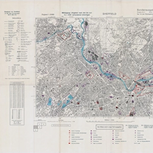
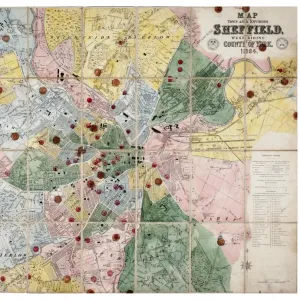
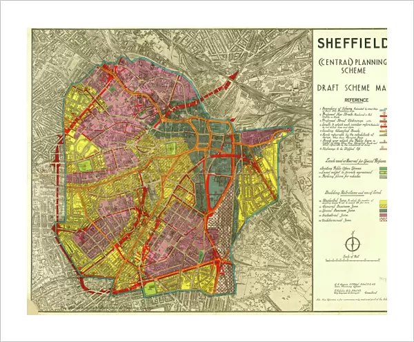
Fine Art Print : Sheffield (Central) Planning Scheme; Draft Scheme Map, 1939
 Planning Scheme; Draft Scheme Map, 1939")

Resolution may be poor at this size (119 DPI)
![]()
Fine Art Prints from Sheffield City Archives
Sheffield (Central) Planning Scheme; Draft Scheme Map, 1939
Published by Sheffield City Council.Scale 200 feet : 1 inch.Original at Sheffield Local Studies Library:s (39) L
Sheffield City Archives and Local Studies Library has an unrivalled collection of images of Sheffield, England
Media ID 14051584
© Sheffield City Council
20"x16" (+3" Border) Fine Art Print
Step back in time with our exquisite Fine Art Print from Media Storehouse, featuring the Sheffield (Central) Planning Scheme Draft Scheme Map of 1939. This intricately detailed and historically significant print, published by Sheffield City Council, offers a captivating glimpse into the city's past planning efforts. With a meticulous scale of 200 feet to 1 inch, this print is not only an essential addition to any local history collection but also a beautiful piece of art that tells a story of urban planning and development. Original map held at Sheffield Local Studies Library (39) L. Acquire this unique piece today and bring a piece of Sheffield's history into your home or office.
20x16 image printed on 26x22 Fine Art Rag Paper with 3" (76mm) white border. Our Fine Art Prints are printed on 300gsm 100% acid free, PH neutral paper with archival properties. This printing method is used by museums and art collections to exhibit photographs and art reproductions.
Our fine art prints are high-quality prints made using a paper called Photo Rag. This 100% cotton rag fibre paper is known for its exceptional image sharpness, rich colors, and high level of detail, making it a popular choice for professional photographers and artists. Photo rag paper is our clear recommendation for a fine art paper print. If you can afford to spend more on a higher quality paper, then Photo Rag is our clear recommendation for a fine art paper print.
Estimated Image Size (if not cropped) is 50.8cm x 40.6cm (20" x 16")
Estimated Product Size is 66cm x 55.9cm (26" x 22")
These are individually made so all sizes are approximate
Artwork printed orientated as per the preview above, with landscape (horizontal) orientation to match the source image.
FEATURES IN THESE COLLECTIONS
> Maps and Charts
> Related Images
> Sheffield City Archives
> Maps and Plans
EDITORS COMMENTS
This print showcases the Sheffield (Central) Planning Scheme's Draft Scheme Map from 1939. Published by the esteemed Sheffield City Council, this historical document offers a glimpse into the city's urban planning efforts during that era. The scale of 200 feet to 1 inch provides intricate details and highlights the meticulousness with which this plan was crafted. Preserved at the prestigious Sheffield Local Studies Library, this original piece holds immense value for researchers and history enthusiasts alike. It serves as a testament to the dedication and foresight of city planners who sought to shape Sheffield's future development. The map itself is a visual feast, revealing an intricate network of streets, buildings, parks, and landmarks that formed the foundation of central Sheffield in 1939. Every street corner tells a story; every block represents countless hours of thoughtful consideration. As we gaze upon this remarkable artifact from yesteryears, it transports us back in time – allowing us to appreciate how far our beloved city has come since then. It reminds us that progress is built upon visionary plans like these and encourages us to reflect on how we can continue shaping our urban landscape for future generations
MADE IN AUSTRALIA
Safe Shipping with 30 Day Money Back Guarantee
FREE PERSONALISATION*
We are proud to offer a range of customisation features including Personalised Captions, Color Filters and Picture Zoom Tools
SECURE PAYMENTS
We happily accept a wide range of payment options so you can pay for the things you need in the way that is most convenient for you
* Options may vary by product and licensing agreement. Zoomed Pictures can be adjusted in the Cart.