Fine Art Print > Aerial Photography > Italy
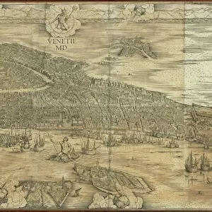
Fine Art Print : Map of Medieval Treviso, from Medieval Treviso by Angelo Marchesan, engraving


![]()
Fine Art Prints from Universal Images Group (UIG)
Map of Medieval Treviso, from Medieval Treviso by Angelo Marchesan, engraving
Cartography, Italy. Map of Medieval Treviso. From Medieval Treviso by Angelo Marchesan. Engraving
Universal Images Group (UIG) manages distribution for many leading specialist agencies worldwide
Media ID 9572471
© DEA / G. FINI
16th Century Aerial View Border Boundary Connection Field Fortified Wall Guidance Human Settlement Medieval Navigational Equipment River Surrounding Wall Text Town Townscape Veneto Wall Western Script Non Urban Scene Treviso
20"x20" (+3" Border) Fine Art Print
Step back in time with our exquisite Fine Art Print of the Map of Medieval Treviso. This intricately detailed engraving, taken from Angelo Marchesan's Medieval Treviso, transports you to the heart of Italy during the Middle Ages. The intricate cartography showcases the layout of the city, complete with its defensive walls, churches, and key landmarks. A beautiful addition to any home or office, this fine art print is a testament to the rich history and artistic tradition of Italy. Order now and bring a piece of the past into your space.
20x20 image printed on 26x26 Fine Art Rag Paper with 3" (76mm) white border. Our Fine Art Prints are printed on 300gsm 100% acid free, PH neutral paper with archival properties. This printing method is used by museums and art collections to exhibit photographs and art reproductions.
Our fine art prints are high-quality prints made using a paper called Photo Rag. This 100% cotton rag fibre paper is known for its exceptional image sharpness, rich colors, and high level of detail, making it a popular choice for professional photographers and artists. Photo rag paper is our clear recommendation for a fine art paper print. If you can afford to spend more on a higher quality paper, then Photo Rag is our clear recommendation for a fine art paper print.
Estimated Image Size (if not cropped) is 50.8cm x 46.5cm (20" x 18.3")
Estimated Product Size is 66cm x 66cm (26" x 26")
These are individually made so all sizes are approximate
Artwork printed orientated as per the preview above, with landscape (horizontal) orientation to match the source image.
FEATURES IN THESE COLLECTIONS
> Aerial Photography
> Related Images
> Arts
> Art Movements
> Landscapes
> Arts
> Art Movements
> Medieval Art
> Arts
> Contemporary art
> Landscapes
> Urban landscapes
> Arts
> Landscape paintings
> Landscape art
> Arts
> Landscape paintings
> Waterfall and river artworks
> Landscape paintings
> Arts
> Landscape paintings
> Waterfall and river artworks
> Arts
> Portraits
> Landscape paintings
> Urban landscapes
> Arts
> Realistic drawings
> Urban landscapes
> Urban artwork
> Universal Images Group (UIG)
> Art
> Painting, Sculpture & Prints
> Cartography
EDITORS COMMENTS
This print showcases a remarkable piece of history - the Map of Medieval Treviso. Taken from Angelo Marchesan's renowned book, "Medieval Treviso" this engraving offers a fascinating glimpse into the past. The map depicts the medieval town of Treviso in Italy during the 16th century, with its intricate topography and surrounding landscape beautifully illustrated. The aerial view allows us to appreciate the town's connection to nature as it sits peacefully amidst fields and a meandering river. The fortified walls that enclose Treviso are prominently displayed, reminding us of its strategic importance during that era. The absence of people in this image adds an air of mystery, allowing our imagination to wander through time and envision life within these ancient boundaries. The detailed cartography provides valuable guidance for understanding the layout and structure of this historical settlement. Western script text accompanies various landmarks on the map, offering further insight into its significance. As we gaze upon this artful representation, we can't help but feel transported back in time - immersed in a world where navigational equipment was rudimentary at best and human settlements were confined by sturdy fortifications. This print is not just an exquisite piece of art; it is also a testament to our enduring fascination with history and our desire to explore different cultures through visual storytelling.
MADE IN AUSTRALIA
Safe Shipping with 30 Day Money Back Guarantee
FREE PERSONALISATION*
We are proud to offer a range of customisation features including Personalised Captions, Color Filters and Picture Zoom Tools
SECURE PAYMENTS
We happily accept a wide range of payment options so you can pay for the things you need in the way that is most convenient for you
* Options may vary by product and licensing agreement. Zoomed Pictures can be adjusted in the Cart.