Fine Art Print > Europe > United Kingdom > England > London > Royalty
Fine Art Print : Africa circa 1725 from Modern Geography


![]()
Fine Art Prints from Universal Images Group (UIG)
Africa circa 1725 from Modern Geography
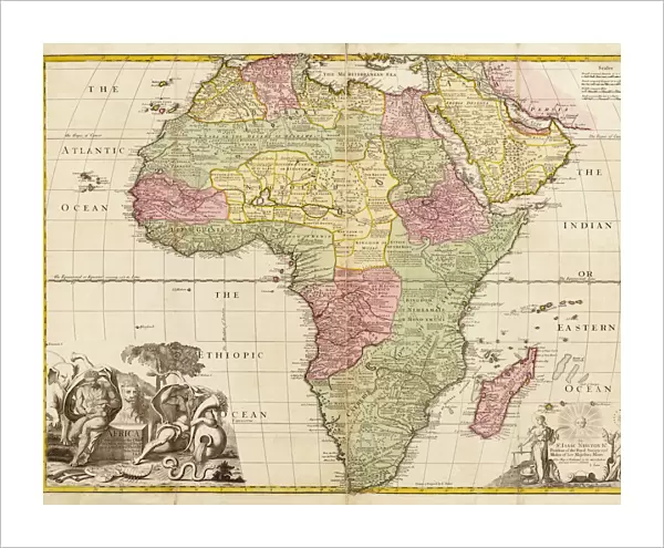
Africa circa 1725 from Modern Geography. Drawn and engraved by John Senex. The map shows boundaries of kingdoms and tribal areas on the continent as they were assumed to be in the early 18th century. Information was based on " observations by the Royal Society of London and Paris."
Universal Images Group (UIG) manages distribution for many leading specialist agencies worldwide
Media ID 20165293
© Ken Welsh / Design Pics
1725 18th Africa African Areas Century Color Colored Colour Coloured Drawn Eighteenth Engraved John Tribal Boundaries Frontiers Kingdoms
20"x16" (+3" Border) Fine Art Print
Step back in time with our exquisite selection of Fine Art Prints from Media Storehouse. This captivating print, titled "Africa circa 1725" from Modern Geography by Universal History Archive, transports you back to the early 18th century. Meticulously drawn and engraved by John Senex, this vintage map showcases the assumed boundaries of African kingdoms and tribal areas during that era. Add an air of history and sophistication to your home or office with this stunning piece of art, a window into the past that tells a story of exploration and discovery. Order now and let history come alive in your space.
20x16 image printed on 26x22 Fine Art Rag Paper with 3" (76mm) white border. Our Fine Art Prints are printed on 300gsm 100% acid free, PH neutral paper with archival properties. This printing method is used by museums and art collections to exhibit photographs and art reproductions.
Our fine art prints are high-quality prints made using a paper called Photo Rag. This 100% cotton rag fibre paper is known for its exceptional image sharpness, rich colors, and high level of detail, making it a popular choice for professional photographers and artists. Photo rag paper is our clear recommendation for a fine art paper print. If you can afford to spend more on a higher quality paper, then Photo Rag is our clear recommendation for a fine art paper print.
Estimated Image Size (if not cropped) is 50.8cm x 40.6cm (20" x 16")
Estimated Product Size is 66cm x 55.9cm (26" x 22")
These are individually made so all sizes are approximate
Artwork printed orientated as per the preview above, with landscape (horizontal) orientation to match the source image.
FEATURES IN THESE COLLECTIONS
> Animals
> Mammals
> Sciuridae
> Senex
> Arts
> Artists
> S
> John Senex
> Europe
> France
> Paris
> Maps
> Europe
> United Kingdom
> England
> London
> Royalty
> Maps and Charts
> Early Maps
> Maps and Charts
> Related Images
> Universal Images Group (UIG)
> History
> Historical Maps
EDITORS COMMENTS
This print showcases a map of Africa circa 1725, as depicted in the renowned work "Modern Geography". Created by the skilled hands of John Senex, this intricately drawn and engraved map offers a glimpse into the continent's boundaries, kingdoms, and tribal areas during the early 18th century. In vibrant colors that bring life to its surface, this historical artifact provides valuable insights into Africa's geopolitical landscape. The delineation of frontiers and territories is based on meticulous observations made by esteemed institutions such as the Royal Society of London and Paris. It serves as a testament to their dedication in unraveling the mysteries of this vast land. As we gaze upon this extraordinary piece, we are transported back in time to an era when exploration was at its peak. We can almost hear whispers of adventure echoing through its colored contours. This map not only represents geographical information but also embodies humanity's insatiable curiosity about distant lands. Through Senex's artistry, we witness his commitment to accuracy and detail. Every line etched onto paper tells a story; every shade chosen evokes emotions tied to discovery and wonderment. This print from Universal History Archive allows us to appreciate both the beauty and significance of cartography in preserving our collective history. It reminds us that maps are not merely tools for navigation but windows into past civilizations—guiding us towards understanding our roots while igniting our desire for further exploration beyond borders yet unknown.
MADE IN AUSTRALIA
Safe Shipping with 30 Day Money Back Guarantee
FREE PERSONALISATION*
We are proud to offer a range of customisation features including Personalised Captions, Color Filters and Picture Zoom Tools
SECURE PAYMENTS
We happily accept a wide range of payment options so you can pay for the things you need in the way that is most convenient for you
* Options may vary by product and licensing agreement. Zoomed Pictures can be adjusted in the Cart.