Photo Mug > Europe > United Kingdom > England > London > Royalty
Photo Mug : Africa circa 1725 from Modern Geography


![]()
Home Decor from Universal Images Group (UIG)
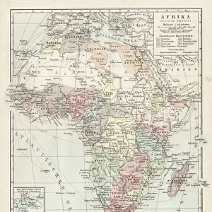
Africa circa 1725 from Modern Geography
Africa circa 1725 from Modern Geography. Drawn and engraved by John Senex. The map shows boundaries of kingdoms and tribal areas on the continent as they were assumed to be in the early 18th century. Information was based on " observations by the Royal Society of London and Paris."
Universal Images Group (UIG) manages distribution for many leading specialist agencies worldwide
Media ID 20165293
© Ken Welsh / Design Pics
1725 18th Africa African Areas Century Color Colored Colour Coloured Drawn Eighteenth Engraved John Tribal Boundaries Frontiers Kingdoms
Photo Mug
Step back in time with our Media Storehouse Photo Mug, featuring an intriguing image from Africa circa 1725. This captivating map, taken from "Modern Geography" by Universal History Archive at Universal Images Group (UIG), showcases the assumed boundaries of kingdoms and tribal areas on the African continent during the early 18th century. Each mug in our Photo Mug range is expertly printed with high-quality images, ensuring your favorite historical maps remain a daily inspiration. Perfect for history enthusiasts, travelers, or anyone who appreciates the beauty of the past, our Photo Mugs make unique and thoughtful gifts. Embrace the rich history of Africa and enjoy your favorite beverage in style with this distinctive and intriguing mug.
A personalised photo mug blends sentimentality with functionality, making an ideal gift for cherished loved ones, close friends, or valued colleagues. Preview may show both sides of the same mug.
Elevate your coffee or tea experience with our premium white ceramic mug. Its wide, comfortable handle makes drinking easy, and you can rely on it to be both microwave and dishwasher safe. Sold in single units, preview may show both sides of the same mug so you can see how the picture wraps around.
Mug Size is 8.1cm high x 9.6cm diameter (3.2" x 3.8")
These are individually made so all sizes are approximate
FEATURES IN THESE COLLECTIONS
> Animals
> Mammals
> Sciuridae
> Senex
> Arts
> Artists
> S
> John Senex
> Europe
> France
> Paris
> Maps
> Europe
> United Kingdom
> England
> London
> Royalty
> Maps and Charts
> Early Maps
> Maps and Charts
> Related Images
> Universal Images Group (UIG)
> History
> Historical Maps
EDITORS COMMENTS
This print showcases a map of Africa circa 1725, as depicted in the renowned work "Modern Geography". Created by the skilled hands of John Senex, this intricately drawn and engraved map offers a glimpse into the continent's boundaries, kingdoms, and tribal areas during the early 18th century. In vibrant colors that bring life to its surface, this historical artifact provides valuable insights into Africa's geopolitical landscape. The delineation of frontiers and territories is based on meticulous observations made by esteemed institutions such as the Royal Society of London and Paris. It serves as a testament to their dedication in unraveling the mysteries of this vast land. As we gaze upon this extraordinary piece, we are transported back in time to an era when exploration was at its peak. We can almost hear whispers of adventure echoing through its colored contours. This map not only represents geographical information but also embodies humanity's insatiable curiosity about distant lands. Through Senex's artistry, we witness his commitment to accuracy and detail. Every line etched onto paper tells a story; every shade chosen evokes emotions tied to discovery and wonderment. This print from Universal History Archive allows us to appreciate both the beauty and significance of cartography in preserving our collective history. It reminds us that maps are not merely tools for navigation but windows into past civilizations—guiding us towards understanding our roots while igniting our desire for further exploration beyond borders yet unknown.
MADE IN AUSTRALIA
Safe Shipping with 30 Day Money Back Guarantee
FREE PERSONALISATION*
We are proud to offer a range of customisation features including Personalised Captions, Color Filters and Picture Zoom Tools
SECURE PAYMENTS
We happily accept a wide range of payment options so you can pay for the things you need in the way that is most convenient for you
* Options may vary by product and licensing agreement. Zoomed Pictures can be adjusted in the Cart.