Fine Art Print > Universal Images Group (UIG) > Universal Images Group > Satellite and Aerial > Planet Observer 6
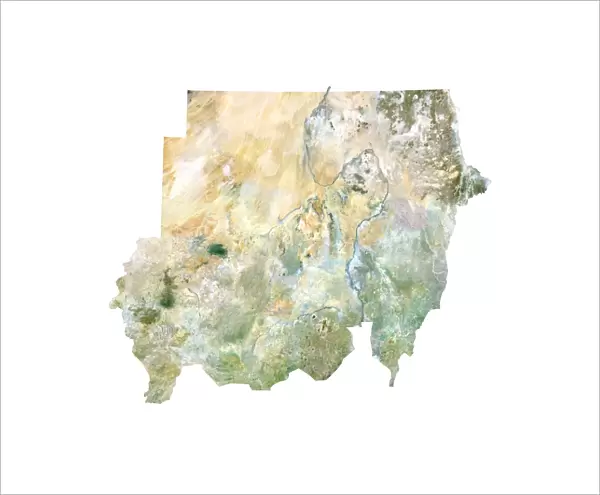
Fine Art Print : Sudan, Satellite Image


![]()
Fine Art Prints from Universal Images Group (UIG)
Sudan, Satellite Image
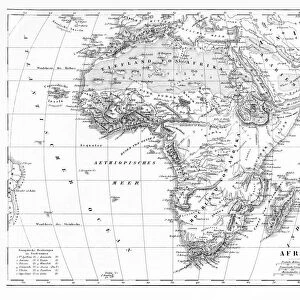
Satellite view of Sudan. This image was compiled from data acquired by LANDSAT satellite
Universal Images Group (UIG) manages distribution for many leading specialist agencies worldwide
Media ID 9615249
© Planet Observer
Alsace Bas Rhin Geographical Border Relief Map Satellite View
20"x16" (+3" Border) Fine Art Print
Discover the captivating beauty of Sudan through our Fine Art Prints from Media Storehouse. This stunning satellite image, sourced from Universal Images Group (UIG), offers a unique perspective of Sudan's diverse landscape. Compiled from data acquired by LANDSAT satellite, this print showcases the intricate patterns of Sudan's terrain, from the vast expanses of desert to the winding rivers and lush greenery. Bring a piece of the world into your home or office with this beautiful and thought-provoking addition to your decor.
20x16 image printed on 26x22 Fine Art Rag Paper with 3" (76mm) white border. Our Fine Art Prints are printed on 300gsm 100% acid free, PH neutral paper with archival properties. This printing method is used by museums and art collections to exhibit photographs and art reproductions.
Our fine art prints are high-quality prints made using a paper called Photo Rag. This 100% cotton rag fibre paper is known for its exceptional image sharpness, rich colors, and high level of detail, making it a popular choice for professional photographers and artists. Photo rag paper is our clear recommendation for a fine art paper print. If you can afford to spend more on a higher quality paper, then Photo Rag is our clear recommendation for a fine art paper print.
Estimated Image Size (if not cropped) is 50.8cm x 36cm (20" x 14.2")
Estimated Product Size is 66cm x 55.9cm (26" x 22")
These are individually made so all sizes are approximate
Artwork printed orientated as per the preview above, with landscape (horizontal) orientation to match the source image.
EDITORS COMMENTS
This print showcases the stunning satellite view of Sudan, a country steeped in rich history and diverse landscapes. Acquired by the LANDSAT satellite, this image offers an intricate topography that unveils Sudan's geographical wonders. From its vast deserts to lush river valleys, this photograph captures the essence of Sudan's physical geography. The color image beautifully highlights the contrasting features found within this North African nation. With no people present, one can fully appreciate the untouched beauty of Sudan's natural landscape. The relief map provides a three-dimensional perspective, allowing viewers to immerse themselves in every contour and elevation change. As we explore this satellite view, it becomes evident how borders shape our understanding of countries and their unique characteristics. This photograph not only serves as a visual delight but also sparks curiosity about political boundaries and their influence on land formations. Universal Images Group (UIG) has once again delivered an exceptional piece that combines cartography with photography seamlessly. Their dedication to capturing these awe-inspiring moments from around the world is commendable
MADE IN AUSTRALIA
Safe Shipping with 30 Day Money Back Guarantee
FREE PERSONALISATION*
We are proud to offer a range of customisation features including Personalised Captions, Color Filters and Picture Zoom Tools
SECURE PAYMENTS
We happily accept a wide range of payment options so you can pay for the things you need in the way that is most convenient for you
* Options may vary by product and licensing agreement. Zoomed Pictures can be adjusted in the Cart.