Fine Art Print > Universal Images Group (UIG) > Universal Images Group > Satellite and Aerial > Planet Observer 6
Fine Art Print : Western Sahara, Relief Map


![]()
Fine Art Prints from Universal Images Group (UIG)
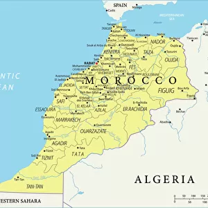
Western Sahara, Relief Map
Relief map of Western Sahara. This map was processed from elevation data
Universal Images Group (UIG) manages distribution for many leading specialist agencies worldwide
Media ID 9634169
© Planet Observer
Alsace Bas Rhin Geographical Border Relief Map Satellite View
20"x16" (+3" Border) Fine Art Print
Discover the enchanting beauty of the Western Sahara with our exquisite Fine Art Print from Media Storehouse. This stunning relief map, sourced from Universal Images Group (UIG), offers a unique perspective of the Western Sahara's intricate terrain. Processed from precise elevation data, each detail is brought to life in vivid colors and exceptional clarity. Bring the mystique of this captivating region into your home or office with this beautiful and thought-provoking addition to your decor. Order now and let the power of fine art transport you to new heights.
20x16 image printed on 26x22 Fine Art Rag Paper with 3" (76mm) white border. Our Fine Art Prints are printed on 300gsm 100% acid free, PH neutral paper with archival properties. This printing method is used by museums and art collections to exhibit photographs and art reproductions.
Our fine art prints are high-quality prints made using a paper called Photo Rag. This 100% cotton rag fibre paper is known for its exceptional image sharpness, rich colors, and high level of detail, making it a popular choice for professional photographers and artists. Photo rag paper is our clear recommendation for a fine art paper print. If you can afford to spend more on a higher quality paper, then Photo Rag is our clear recommendation for a fine art paper print.
Estimated Image Size (if not cropped) is 50.8cm x 36cm (20" x 14.2")
Estimated Product Size is 66cm x 55.9cm (26" x 22")
These are individually made so all sizes are approximate
Artwork printed orientated as per the preview above, with landscape (horizontal) orientation to match the source image.
EDITORS COMMENTS
This print showcases the intricate details of a relief map of Western Sahara, offering a unique perspective on this fascinating region. Processed from elevation data, the map beautifully captures the topography and physical geography of Western Sahara. The vibrant colors and precise cartography make it an excellent tool for studying and understanding the landforms that shape this part of Africa. Taken in Alsace, France by Universal Images Group (UIG), this vertical photograph highlights their exceptional photography skills. With no people present in the frame, all attention is drawn to the relief map itself, allowing viewers to immerse themselves in its intricacies. The satellite view adds another layer of depth to this image as it enables us to appreciate how geographical borders are defined within Western Sahara's vast expanse. The outdoors setting further enhances our connection with nature and reminds us of the importance of preserving such remarkable landscapes. It is worth noting that this caption does not mention any commercial use or affiliation with a specific company but focuses solely on appreciating the beauty and educational value offered by this particular print from Universal Images Group (UIG). Whether you are an enthusiast seeking knowledge about Western Sahara or simply captivated by maps and topography, this stunning image will undoubtedly leave you awe-inspired.
MADE IN AUSTRALIA
Safe Shipping with 30 Day Money Back Guarantee
FREE PERSONALISATION*
We are proud to offer a range of customisation features including Personalised Captions, Color Filters and Picture Zoom Tools
SECURE PAYMENTS
We happily accept a wide range of payment options so you can pay for the things you need in the way that is most convenient for you
* Options may vary by product and licensing agreement. Zoomed Pictures can be adjusted in the Cart.