Jigsaw Puzzle > Universal Images Group (UIG) > Universal Images Group > Satellite and Aerial > Planet Observer 6
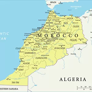
Jigsaw Puzzle : Western Sahara, Relief Map


![]()
Jigsaw Puzzles from Universal Images Group (UIG)
Western Sahara, Relief Map
Relief map of Western Sahara. This map was processed from elevation data
Universal Images Group (UIG) manages distribution for many leading specialist agencies worldwide
Media ID 9634169
© Planet Observer
Alsace Bas Rhin Geographical Border Relief Map Satellite View
Jigsaw Puzzle (500 Pieces)
Discover the intricacies of geography with our Media Storehouse Jigsaw Puzzles! This stunning Western Sahara Relief Map puzzle, brought to you by Universal Images Group, offers an educational and engaging experience. Featuring a detailed and accurate relief map of the Western Sahara, processed from elevation data, this puzzle is perfect for those who love geography, history, or simply enjoy a challenge. With a variety of pieces and intricate details, this puzzle is sure to provide hours of fun and satisfaction as you piece together the diverse terrain of this unique region. Bring the world into your home with our high-quality, beautifully designed jigsaw puzzles.
500 piece puzzles are custom made in Australia and hand-finished on 100% recycled 1.6mm thick laminated puzzle boards. There is a level of repetition in jigsaw shapes with each matching piece away from its pair. The completed puzzle measures 40x51cm and is delivered packaged in an attractive presentation box specially designed to fit most mail slots with a unique magnetic lid
Jigsaw Puzzles are an ideal gift for any occasion
Estimated Product Size is 50.7cm x 40.3cm (20" x 15.9")
These are individually made so all sizes are approximate
Artwork printed orientated as per the preview above, with landscape (horizontal) or portrait (vertical) orientation to match the source image.
EDITORS COMMENTS
This print showcases the intricate details of a relief map of Western Sahara, offering a unique perspective on this fascinating region. Processed from elevation data, the map beautifully captures the topography and physical geography of Western Sahara. The vibrant colors and precise cartography make it an excellent tool for studying and understanding the landforms that shape this part of Africa. Taken in Alsace, France by Universal Images Group (UIG), this vertical photograph highlights their exceptional photography skills. With no people present in the frame, all attention is drawn to the relief map itself, allowing viewers to immerse themselves in its intricacies. The satellite view adds another layer of depth to this image as it enables us to appreciate how geographical borders are defined within Western Sahara's vast expanse. The outdoors setting further enhances our connection with nature and reminds us of the importance of preserving such remarkable landscapes. It is worth noting that this caption does not mention any commercial use or affiliation with a specific company but focuses solely on appreciating the beauty and educational value offered by this particular print from Universal Images Group (UIG). Whether you are an enthusiast seeking knowledge about Western Sahara or simply captivated by maps and topography, this stunning image will undoubtedly leave you awe-inspired.
MADE IN AUSTRALIA
Safe Shipping with 30 Day Money Back Guarantee
FREE PERSONALISATION*
We are proud to offer a range of customisation features including Personalised Captions, Color Filters and Picture Zoom Tools
SECURE PAYMENTS
We happily accept a wide range of payment options so you can pay for the things you need in the way that is most convenient for you
* Options may vary by product and licensing agreement. Zoomed Pictures can be adjusted in the Cart.