Fraud Blocker Skip to main content

Home > Arts > Realistic drawings > Pencil drawings > Fine art
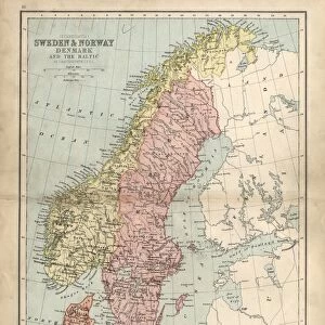
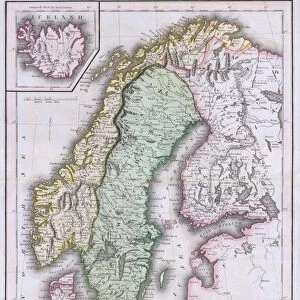
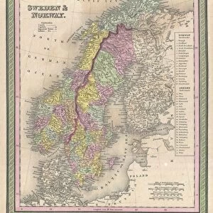
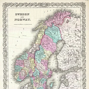
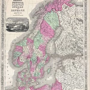
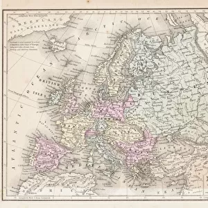
Sweden and Norway

Sweden and Norway


Framed Photos
Photo Prints
Jigsaw Puzzles
Poster Prints
Canvas Prints
Fine Art Prints
Metal Prints
Cards
Home Decor


We accept all major credit cards

Fine Art Storehouse

Wall Art and Photo Gifts from Fine Art Storehouse

Sweden and Norway

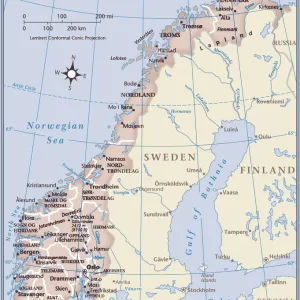
Antique map of Sweden and Norway

Unleash your creativity and transform your space into a visual masterpiece!

Nastasic

Media ID 13592355

© Nikola Nastasic

Aging Process Antiquities Arctic Art Product Atlas Baltic Countries Cartographer Chart Computer Graphic Computer Graphics Fashioned Illustrated Monoprint North Norway Origins Painting Paintings Pencil Drawing Pictorial Picture Printout Revival Sweden Territorial Territorial Animal Topography World Map Drawing Art Product Obsolete Painted Image Retro Styled


FEATURES IN THESE COLLECTIONS

> Arts > Realistic drawings > Pencil drawings > Fine art

> Europe > Norway > Maps

> Europe > Norway > Paintings

> Europe > Sweden > Maps

> Europe > Sweden > Paintings

> Fine Art Storehouse > The Magical World of Illustration > Nastasic Images & Illustrations

> Fine Art Storehouse > Map > Historical Maps

> Fine Art Storehouse > Map

> Maps and Charts > Early Maps

> Maps and Charts > Norway

> Maps and Charts > Sweden

> Maps and Charts > World


EDITORS COMMENTS
This print transports us back in time to the rich history and ancient cultures of Sweden and Norway. The antique map, beautifully crafted with retro styling, showcases the artistry of cartography from a bygone era. The revival of this territorial masterpiece brings to life a painted image that once guided explorers through these Nordic lands. The intricate details etched into the illustration reveal the topography and physical geography of this breathtaking region. From pencil drawings to engravings, every stroke tells a story of the arctic landscapes and vast seas that define Sweden and Norway. As we gaze upon this monoprint, we are reminded of the aging process that has transformed these countries throughout history. It is an homage to their origins, capturing both their ancient roots and their place in modern Europe. The old-world charm emanating from this artwork evokes a sense of nostalgia for times long past. It invites us to delve into the depths of our own imaginations as we explore the cultural heritage embedded within each line on this meticulously designed chart. Nastasic's creation seamlessly blends computer graphics with traditional art techniques, resulting in a picture that is both timeless and contemporary. This print serves as a testament to our enduring fascination with maps as not just tools but also works of art – reminders of our connection to the world around us.

MADE IN AUSTRALIA
Safe Shipping with 30 Day Money Back Guarantee

FREE PERSONALISATION*
We are proud to offer a range of customisation features including Personalised Captions, Color Filters and Picture Zoom Tools

SECURE PAYMENTS
We happily accept a wide range of payment options so you can pay for the things you need in the way that is most convenient for you

* Options may vary by product and licensing agreement. Zoomed Pictures can be adjusted in the Cart.


redeem
Beautiful Photo Prints and Gifts
image
Professionally Printed
thumb_up
Professional quality finish
diamond
Made with high-grade materials
inventory_2
Carefully packed to aid safe arrival


Related Images


Prussia historical map
Map of Sweden with Denmark and Norway
Antique damaged map of Swden Norway Denmark 19th Century
Sweden - Infographic map - illustration
1730, Homann Map of Scandinavia, Norway, Sweden, Denmark, Finland and the Baltics
1794, Laurie and Whittle Map of Norway, Sweden, Denmark and Finland, 1794 - 1812
1827, Finley Map of Scandinavia, Norway, Sweden, Denmark, Anthony Finley mapmaker
1840, Lizars Map of Scandinavia, Norway, Sweden, Finland, Denmark, Iceland, topography
1850, Mitchell Map of Scandinavia, Norway, Sweden, Denmark, Finland, topography, cartography
1851, Black Map of Norway and Sweden, Scandinavia, topography, cartography, geography
1855, Colton Map of Scandinavia, Norway, Sweden, Finland, topography, cartography
1864, Johnson Map of Scandinavia, Norway, Sweden, Denmark, Prussia, topography, cartography

+

Shipping

+

Choices

+

Reviews

+

Guaranteed


Related Collections


Early Maps
Early Maps
Browse 24,907 Prints
Nastasic Images & Illustrations
Browse 2,706 Prints
Map
Map
Browse 9,856 Prints
Maps
Maps
Browse 336 Prints
Maps
Maps
Browse 397 Prints
Paintings
Paintings
Browse 1,657 Prints
Paintings
Paintings
Browse 5,977 Prints
Norway
Norway
Browse 316 Prints
Sweden
Sweden
Browse 352 Prints
World
World
Browse 6,163 Prints
Historical Maps
Historical Maps
Browse 3,307 Prints
Fine art
Fine art
Browse 2,490 Prints