Home > Europe > Norway > Maps
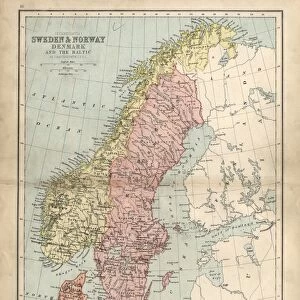
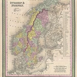
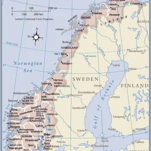
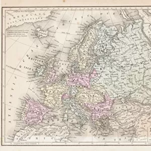
1827, Finley Map of Scandinavia, Norway, Sweden, Denmark, Anthony Finley mapmaker

![]()
Wall Art and Photo Gifts from Liszt Collection
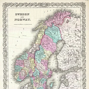
1827, Finley Map of Scandinavia, Norway, Sweden, Denmark, Anthony Finley mapmaker
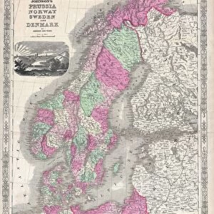
1827, Finley Map of Scandinavia, Norway, Sweden, Denmark, Anthony Finley mapmaker of the United States in the 19th century
Liszt Collection of nineteenth-century engravings and images to browse and enjoy
Media ID 14005020
© Artokoloro Quint Lox Limited
1827 Denmark Norway Sweden Antique Map Atlas Chart Geographic Latitude Longitude Mappa Mundi Old Antique Plan Old Antique View Old Map Ols Antique Map Rare Old Maps Topo
FEATURES IN THESE COLLECTIONS
> Maps and Charts
> Early Maps
> Maps and Charts
> World
EDITORS COMMENTS
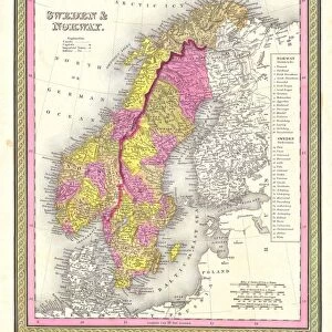
This print showcases the 1827 Finley Map of Scandinavia, a remarkable creation by Anthony Finley, an esteemed mapmaker from the United States in the 19th century. The intricately detailed map encompasses Norway, Sweden, and Denmark, offering a glimpse into the geographical wonders of this enchanting region. With its topography meticulously depicted and cartography skillfully executed, this vintage piece serves as both an artful illustration and a valuable geographic resource. Every contour and grid line on this antique map reflects Finley's dedication to accuracy and precision. As we gaze upon this aged treasure, we are transported back in time to an era when exploration was at its peak. This historic document takes us on a journey through space and time, inviting us to discover new lands and regions that were once uncharted territories. The delicate paper texture adds to the charm of this decorative piece while evoking nostalgia for times gone by. It reminds us of the importance of navigation in ancient history and how maps like these played a crucial role in guiding travelers across vast distances. This rare old map is not just an artifact; it represents our collective fascination with discovery and exploration. Its presence ignites our curiosity about different cultures, landscapes, and histories that have shaped our world today. Let this exquisite print serve as a reminder of our innate desire to explore beyond boundaries – both physical and metaphorical – as we continue charting new territories in life's grand adventure.
MADE IN AUSTRALIA
Safe Shipping with 30 Day Money Back Guarantee
FREE PERSONALISATION*
We are proud to offer a range of customisation features including Personalised Captions, Color Filters and Picture Zoom Tools
SECURE PAYMENTS
We happily accept a wide range of payment options so you can pay for the things you need in the way that is most convenient for you
* Options may vary by product and licensing agreement. Zoomed Pictures can be adjusted in the Cart.