Home > Arts > Artists > P > those present
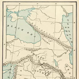
Antique map of coast of present day Lebanon and Syria

![]()
Wall Art and Photo Gifts from Fine Art Storehouse
Antique map of coast of present day Lebanon and Syria
Unleash your creativity and transform your space into a visual masterpiece!
Hemera Technologies
Media ID 13609497
© Getty Images
Direction Document Geography Lebanon Lebanon Country Legend Location Mediterranean Sea Place Positioning Ship Ships Syria Text Title Turkey Turkey Middle East Words
FEATURES IN THESE COLLECTIONS
> Arts
> Artists
> P
> those present
> Asia
> Turkey
> Related Images
> Europe
> Related Images
> Fine Art Storehouse
> Map
> Historical Maps
> Maps and Charts
> Early Maps
EDITORS COMMENTS
This antique map takes us back in time to the coast of present-day Lebanon and Syria. A true testament to the artistry of cartography, this archival print showcases intricate details that transport us to a bygone era. The engraving skillfully depicts the geography of this historic region, with its stunning coastline along the Mediterranean Sea. The map's key and legend provide valuable insights into the location's significance, while carefully placed text and titles guide our exploration. Ships gracefully navigate these waters, reminding us of their historical importance for trade and travel. Turkey, positioned prominently on this vintage map, serves as a gateway between Europe and the Middle East. Its inclusion highlights both its geographical proximity and cultural influence on this coastal area. As we delve deeper into this visual treasure trove, we can't help but appreciate how it captures history unfolding outdoors. The absence of people allows us to focus solely on nature's beauty: from sandy beaches stretching along the shorelines to physical features shaping the landscape. With its vibrant colors preserved over time, this vertical print is a remarkable addition to any collection celebrating history or geography enthusiasts alike. Hemera Technologies has masterfully preserved an invaluable piece of our past through their meticulous restoration process - allowing us to admire and learn from this mesmerizing antique map for generations to come.
MADE IN AUSTRALIA
Safe Shipping with 30 Day Money Back Guarantee
FREE PERSONALISATION*
We are proud to offer a range of customisation features including Personalised Captions, Color Filters and Picture Zoom Tools
SECURE PAYMENTS
We happily accept a wide range of payment options so you can pay for the things you need in the way that is most convenient for you
* Options may vary by product and licensing agreement. Zoomed Pictures can be adjusted in the Cart.