Home > Africa > Madagascar > Maps
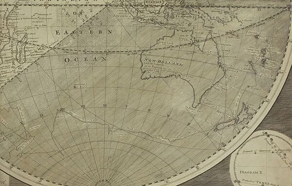
Antique map of Indian Ocean in southern hemisphere
![]()

Wall Art and Photo Gifts from Fine Art Storehouse
Antique map of Indian Ocean in southern hemisphere
Unleash your creativity and transform your space into a visual masterpiece!
Hemera Technologies
Media ID 13609505
© Getty Images
Antarctica Archipelago Australia Circle Cropped Document Geography Indian Ocean Indonesia Latitude Legend Longitude Madagascar New Zealand Round Shape South Pole Southern Hemisphere
FEATURES IN THESE COLLECTIONS
> Africa
> Madagascar
> Maps
> Fine Art Storehouse
> Map
> Historical Maps
> Maps and Charts
> Early Maps
> Oceania
> New Zealand
> Maps
EDITORS COMMENTS
This print showcases an exquisite antique map of the Indian Ocean in the southern hemisphere. With its intricate details and historical significance, this archival piece takes us on a journey through time and geography. The engraving beautifully depicts the vastness of the ocean, bordered by fascinating lands such as Antarctica, Australia, Indonesia, Madagascar, and New Zealand. The carefully cropped document highlights the round shape of our planet while emphasizing the South Pole's importance in this region. A key and legend accompany this map, providing valuable information about latitude and longitude coordinates. The color image adds vibrancy to this historic artifact without compromising its authenticity. As we delve into history through cartography, we are reminded of how far humanity has come in understanding physical geography. This photograph invites us to appreciate not only the artistry involved in creating such maps but also their crucial role in shaping our knowledge of past civilizations. Displayed horizontally with no people present, this particular part of Hemera Technologies' collection offers a glimpse into a world long gone yet still relevant today. It serves as a testament to human curiosity and exploration throughout centuries. Whether you are an avid history enthusiast or simply admire beautiful works of art, this antique map print is sure to captivate your imagination for years to come.
MADE IN AUSTRALIA
Safe Shipping with 30 Day Money Back Guarantee
FREE PERSONALISATION*
We are proud to offer a range of customisation features including Personalised Captions, Color Filters and Picture Zoom Tools
SECURE PAYMENTS
We happily accept a wide range of payment options so you can pay for the things you need in the way that is most convenient for you
* Options may vary by product and licensing agreement. Zoomed Pictures can be adjusted in the Cart.

