Home > North America > Canada > Maps
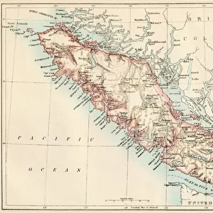
British Columbia map 1897

![]()
Wall Art and Photo Gifts from Fine Art Storehouse
British Columbia map 1897
The World-Wide Atlas of Modern Geography, Political and Physical W. & A.K. Johnston - London 1897
Unleash your creativity and transform your space into a visual masterpiece!
THEPALMER
Media ID 14757122
© Roberto A Sanchez
Alberta Atlas British Columbia Canada Country Geographic Area Earth North America Paper World Map Retro Styled
FEATURES IN THESE COLLECTIONS
> Europe
> United Kingdom
> England
> London
> Related Images
> Fine Art Storehouse
> Map
> Historical Maps
> Maps and Charts
> Early Maps
> Maps and Charts
> World
> North America
> Canada
> Maps
EDITORS COMMENTS
This print takes us back in time to the year 1897, when cartography was an art form and exploration of the world's geography was still a thrilling endeavor. The image showcases a meticulously engraved map of British Columbia, Canada, extracted from "The World-Wide Atlas of Modern Geography" by W. & A. K. Johnston - a renowned London-based publisher at that time. With its retro-styled charm and antique appeal, this print exudes nostalgia and invites us to delve into the rich history of this region. Every detail is etched onto paper with precision and care, capturing not only the physical geography but also the political boundaries that defined British Columbia in that era. As we gaze upon this engraving, our eyes are drawn to the vastness of North America unfolding before us. We can trace our fingers along Alberta's borders as it neighbors its western counterpart. The intricate lines depict rivers snaking through dense forests while mountain ranges rise majestically towards the sky. Beyond being a mere representation on paper, this artwork transports us to another time; it reminds us of how much has changed since then while celebrating the enduring beauty of Earth's landscapes. It serves as a reminder that even in today's digital age, there is something truly special about holding an old-fashioned map in your hands – connecting you not only to places but also to stories untold.
MADE IN AUSTRALIA
Safe Shipping with 30 Day Money Back Guarantee
FREE PERSONALISATION*
We are proud to offer a range of customisation features including Personalised Captions, Color Filters and Picture Zoom Tools
SECURE PAYMENTS
We happily accept a wide range of payment options so you can pay for the things you need in the way that is most convenient for you
* Options may vary by product and licensing agreement. Zoomed Pictures can be adjusted in the Cart.