Framed Print > North America > Cuba > Cuba Heritage Sites > Old Havana and its Fortification System
Framed Print : Geography Atlas: description of the Caribbean Sea, Caribbean Sea (Cuba, Jamaica, Hispaniola, Jamaica), the Bahamas Islands and the Lesser Antilles with map. Plate taken from an Atlas from 1787-1810. Biblioteca Jose Marti, Havana, Cuba
, the Bahamas Islands and the Lesser Antilles with map. Plate taken from an Atlas from 1787-1810. Biblioteca Jose Marti, Havana, Cuba")
, the Bahamas Islands and the Lesser Antilles with map. Plate taken from an Atlas from 1787-1810. Biblioteca Jose Marti, Havana, Cuba")

![]()
Framed Photos From Fine Art Finder
Geography Atlas: description of the Caribbean Sea, Caribbean Sea (Cuba, Jamaica, Hispaniola, Jamaica), the Bahamas Islands and the Lesser Antilles with map. Plate taken from an Atlas from 1787-1810. Biblioteca Jose Marti, Havana, Cuba
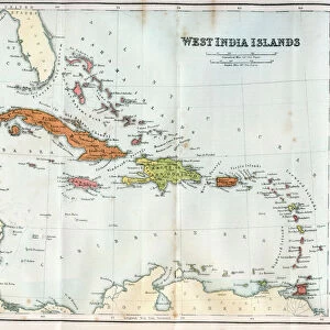
VEN5031247 Geography Atlas: description of the Caribbean Sea, Caribbean Sea (Cuba, Jamaica, Hispaniola, Jamaica), the Bahamas Islands and the Lesser Antilles with map. Plate taken from an Atlas from 1787-1810. Biblioteca Jose Marti, Havana, Cuba.; (add.info.: Geography Atlas: description of the Caribbean Sea, Caribbean Sea (Cuba, Jamaica, Hispaniola, Jamaica), the Bahamas Islands and the Lesser Antilles with map. Plate taken from an Atlas from 1787-1810. Biblioteca Jose Marti, Havana, Cuba.); © Marage Photos
Media ID 38425766
© © Marage Photos / Bridgeman Images
Amerique Centrale Amerique Du Nord Caraïbes Caribbean Caribbean Island Carte Geographique Central America Cuba Cuba Cubain Cubaine Cubains Cubaines Cuban Etats Unis Geographie Jamaica Jamaican Stockravenna 18eme Siecle Geographical Map
A2 Premium Frame with A3 Poster
Transport yourself back in time with this stunning framed print from the Media Storehouse collection. Featuring a detailed map of the Caribbean Sea and surrounding islands, this piece is sure to add a touch of vintage charm to any space. Perfect for history buffs and travel enthusiasts alike!
Premium Paradise Wooden Range A2 Premium Poster Frame (62x45cm) with A3 Poster (42x30cm) and mounted behind a white matt board to make your photo really stand out. FSC Certified and Rainforest Alliance Certified for environmental, social, and economic sustainably. High transparency tempered glass window with a smooth finished frame. Great for filling empty walls, decorating blank spaces, or creating eye-catching gallery walls. Frames arrive ready to hang. Sent with secure, protective packaging. Smooth wooden veneer mimics the real wood look and feel with ultra-durable scratch resistance tempered glass.
Contemporary Framed and Mounted Prints - Professionally Made and Ready to Hang
Estimated Image Size (if not cropped) is 40.4cm x 40.4cm (15.9" x 15.9")
Estimated Product Size is 62cm x 44.6cm (24.4" x 17.6")
These are individually made so all sizes are approximate
Artwork printed orientated as per the preview above, with landscape (horizontal) or portrait (vertical) orientation to match the source image.
FEATURES IN THESE COLLECTIONS
> Fine Art Finder
> Artists
> Pasquier (workshop of) Grenier
> Maps and Charts
> Early Maps
> Maps and Charts
> Related Images
> North America
> The Bahamas
> Maps
> North America
> The Bahamas
> Related Images
> North America
> Cuba
> Cuba Heritage Sites
> Old Havana and its Fortification System
> North America
> Cuba
> Havana
> North America
> Cuba
> Maps
> North America
> Cuba
> Related Images
> North America
> Jamaica
> Maps
EDITORS COMMENTS
This stunning print captures a plate from an Atlas dating back to 1787-1810, showcasing the Geography Atlas description of the Caribbean Sea. The map includes details of the Caribbean Sea, Cuba, Jamaica, Hispaniola, the Bahamas Islands, and the Lesser Antilles.
The intricate engraving provides a glimpse into the geographical layout of these islands during the 18th century. The detailed representation offers a historical perspective on how these regions were depicted centuries ago.
Displayed in the Biblioteca Jose Marti in Havana, Cuba, this piece is not just a visual treat but also serves as a valuable historical artifact. It gives us insight into how cartographers viewed and mapped out these areas before modern technology revolutionized map-making.
The vibrant colors and intricate details on this map are truly mesmerizing. From the lush landscapes of Jamaica to the sprawling coastlines of Cuba and Hispaniola, every element is meticulously illustrated.
As we gaze upon this image, we are transported back in time to an era when exploration and discovery shaped our understanding of geography. This print is not just a beautiful work of art but also a window into our past that continues to fascinate and inspire us today.
MADE IN AUSTRALIA
Safe Shipping with 30 Day Money Back Guarantee
FREE PERSONALISATION*
We are proud to offer a range of customisation features including Personalised Captions, Color Filters and Picture Zoom Tools
SECURE PAYMENTS
We happily accept a wide range of payment options so you can pay for the things you need in the way that is most convenient for you
* Options may vary by product and licensing agreement. Zoomed Pictures can be adjusted in the Basket.