Framed Print > Arts > Artists > M > Herman Moll
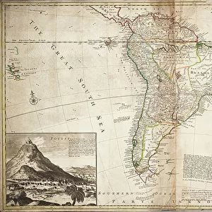
Framed Print : A Double-Page Map of North America, c. 1708-20 (hand-coloured engraving)
")
")

![]()
Framed Photos from Fine Art Finder
A Double-Page Map of North America, c. 1708-20 (hand-coloured engraving)
986383 A Double-Page Map of North America, c.1708-20 (hand-coloured engraving) by English School, (18th century); 66x54 cm; Private Collection; (add.info.: A Double-Page Map of North America. A plate from The World described: or, a new and correct sett of maps, by Herman Moll. J. & T. Bowles. Hand-coloured engraving. Maps dated 1708-1720. 66 x 54cm.); Photo eChristies Images; English, out of copyright
Media ID 23686800
© Christie's Images / Bridgeman Images
1700s 1720 1720s Double Page Early Eighteenth Century Full Frame Geographic Hand Colored Hand Coloring Hand Coloured Hand Colouring Hand Tinted Handcolored Language Lettering Navigational Equipment Page Plate Prints Word 1708
A2 Premium Frame with A3 Poster
Discover the rich history of North America with our stunning Framed Print of a Double-Page Map from Bridgeman Images. This intricately detailed hand-coloured engraving, dating back to the 18th century, offers a captivating glimpse into the cartographic knowledge of the time. The map, sourced from Fine Art Finder, showcases North America in all its complexity, making it a must-have addition to any home or office. Transport yourself back in time and add a touch of history to your space with this beautiful and authentic work of art.
Premium Paradise Wooden Range A2 Premium Poster Frame (62x45cm) with A3 Poster (42x30cm) and mounted behind a white matt board to make your photo really stand out. FSC Certified and Rainforest Alliance Certified for environmental, social, and economic sustainably. High transparency tempered glass window with a smooth finished frame. Great for filling empty walls, decorating blank spaces, or creating eye-catching gallery walls. Frames arrive ready to hang. Sent with secure, protective packaging. Smooth wooden veneer mimics the real wood look and feel with ultra-durable scratch resistance tempered glass.
Contemporary Framed and Mounted Prints - Professionally Made and Ready to Hang
Estimated Image Size (if not cropped) is 40.4cm x 40.4cm (15.9" x 15.9")
Estimated Product Size is 62cm x 44.6cm (24.4" x 17.6")
These are individually made so all sizes are approximate
Artwork printed orientated as per the preview above, with landscape (horizontal) or portrait (vertical) orientation to match the source image.
FEATURES IN THESE COLLECTIONS
> Fine Art Finder
> Artists
> English School
> Fine Art Finder
> Artists
> William Blake
> Fine Art Finder
> Temp Classification
> Arts
> Artists
> M
> Herman Moll
> Maps and Charts
> Early Maps
> Maps and Charts
> World
> North America
> Related Images
EDITORS COMMENTS
This print showcases a double-page map of North America, dating back to the early 18th century. The hand-coloured engraving, created by an English School artist, measures 66x54 cm and is part of a private collection. It is a plate from "The World described: or, a new and correct sett of maps" by Herman Moll, published by J. & T. Bowles. The intricate details of this map are truly remarkable. With its close-up view, one can appreciate the artistry involved in hand-tinting and colouring each section meticulously. Navigational equipment symbols are scattered across the map's surface, reflecting the importance of exploration during that era. The lettering on this piece adds another layer of historical significance as it provides essential information about geographical locations throughout North America. The use of language further enhances our understanding of how cartography was evolving during the 18th century. As we examine this image closely, we are transported back in time to an era when maps were not only functional tools but also works of art themselves. The absence of people allows us to focus solely on the beauty and accuracy captured within this print. Overall, this photograph offers a glimpse into history through its depiction of an exquisitely crafted map that played a vital role in shaping our knowledge and understanding of North America during the early eighteenth century.
MADE IN AUSTRALIA
Safe Shipping with 30 Day Money Back Guarantee
FREE PERSONALISATION*
We are proud to offer a range of customisation features including Personalised Captions, Color Filters and Picture Zoom Tools
SECURE PAYMENTS
We happily accept a wide range of payment options so you can pay for the things you need in the way that is most convenient for you
* Options may vary by product and licensing agreement. Zoomed Pictures can be adjusted in the Cart.