Framed Print > Fine Art Storehouse > Map
Framed Print : West Indies map 1855


![]()
Framed Photos from Fine Art Storehouse
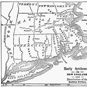
West Indies map 1855
System of Geography for the use of schools by Sidney E. Morse - Published by Harper & Brothers - New York 1855
Unleash your creativity and transform your space into a visual masterpiece!
THEPALMER
Media ID 13668809
© Roberto A Sanchez
Antilles Bahamas Barbados Bermuda Caribbean Sea Cuba Florida Us State Florida Usa Gulf Coast States Haiti Island Puerto Rico Textured Effect Trinidad And Tobago West Indies Obsolete
A2 Premium Frame with A3 Poster
Discover the rich history of cartography with our stunning framed print of the "West Indies Map 1855" by THEPALMER from our Media Storehouse collection. This intricately detailed map, originally published in "System of Geography for the use of schools" by Sidney E. Morse and printed by Harper & Brothers in New York, 1855, offers a captivating glimpse into the geography of the West Indies during a pivotal period in history. Each print is carefully framed to preserve and showcase the beauty and historical significance of this vintage map, making it a perfect addition to any home or office space. Bring a touch of history and sophistication to your decor with our Framed Print of West Indies Map 1855.
Premium Paradise Wooden Range A2 Premium Poster Frame (62x45cm) with A3 Poster (42x30cm) and mounted behind a white matt board to make your photo really stand out. FSC Certified and Rainforest Alliance Certified for environmental, social, and economic sustainably. High transparency tempered glass window with a smooth finished frame. Great for filling empty walls, decorating blank spaces, or creating eye-catching gallery walls. Frames arrive ready to hang. Sent with secure, protective packaging. Smooth wooden veneer mimics the real wood look and feel with ultra-durable scratch resistance tempered glass.
Contemporary Framed and Mounted Prints - Professionally Made and Ready to Hang
Estimated Image Size (if not cropped) is 40.4cm x 40.4cm (15.9" x 15.9")
Estimated Product Size is 62cm x 44.6cm (24.4" x 17.6")
These are individually made so all sizes are approximate
Artwork printed orientated as per the preview above, with landscape (horizontal) or portrait (vertical) orientation to match the source image.
FEATURES IN THESE COLLECTIONS
> Fine Art Storehouse
> The Magical World of Illustration
> Palmer Illustrated Collection
> Fine Art Storehouse
> Map
> Historical Maps
EDITORS COMMENTS
This print takes us back in time to the year 1855, showcasing an antique map of the West Indies. The map is a part of the "System of Geography for the use of schools" by Sidney E. Morse and was published by Harper & Brothers in New York during that era. With its engraved image and textured effect, this piece exudes a sense of history and nostalgia. The intricately detailed cartography highlights various islands within the West Indies, including Trinidad and Tobago, Haiti, Bermuda, Puerto Rico, Cuba, Barbados, and many more. It provides a glimpse into the physical geography of these regions as they were perceived over 150 years ago. As we explore this old map's contours and lines, it becomes apparent how much has changed since then. Some areas have become obsolete or undergone significant transformations over time. Yet amidst these changes lies an enduring beauty that still resonates today. The horizontal composition allows us to take in every detail with ease while emphasizing the vastness of this Caribbean sea region. From Florida's Gulf Coast states to distant shores like Bahamas and Antilles - each island holds its own unique charm waiting to be explored. "The West Indies Map 1855" transports us on a journey through time; it serves as a reminder not only of our ever-changing world but also our timeless fascination with exploration and discovery.
MADE IN AUSTRALIA
Safe Shipping with 30 Day Money Back Guarantee
FREE PERSONALISATION*
We are proud to offer a range of customisation features including Personalised Captions, Color Filters and Picture Zoom Tools
SECURE PAYMENTS
We happily accept a wide range of payment options so you can pay for the things you need in the way that is most convenient for you
* Options may vary by product and licensing agreement. Zoomed Pictures can be adjusted in the Cart.