Framed Print > Fine Art Storehouse > Map
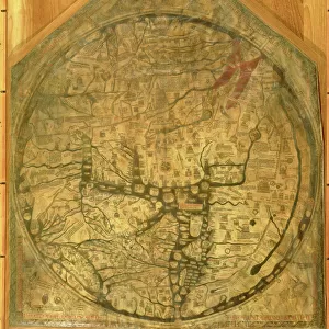
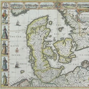
Framed Print : Antique map of Scandinavian region with Iceland and Greenland


![]()
Framed Photos from Fine Art Storehouse
Antique map of Scandinavian region with Iceland and Greenland
Unleash your creativity and transform your space into a visual masterpiece!
Hemera Technologies
Media ID 13597663
© Getty Images
Atlantic Ocean British Isles Canada Concentric Countries Denmark Document Finland Flag Geographical Locations Geography Great Britain Greenland Iceland Legend Line Lines Longitude Nations North Sea Norway Norwegian Sea Patriotism Pole Region Scandinavian Sweden Baffin Bay Radiating
21.5"x17.5" (55x44cm) Premium Frame
Step back in time with our Antique Map of the Scandinavian Region, featuring Iceland and Greenland, from the Fine Art Storehouse by Media Storehouse. This exquisite framed print showcases intricate cartography from a bygone era, transporting you to a time of exploration and discovery. The detailed depiction of the Scandinavian lands, including Iceland and Greenland, adds a touch of history and sophistication to any room. Crafted with care, this antique map print is a beautiful addition to your home or office decor. Bring history to life with this charming piece from the Fine Art Storehouse.
Framed and mounted 17x12 print. Professionally handmade full timber moulded frames are finished off with framers tape and come with a hanging solution on the back. Outer dimensions are 21.5x17.5 inches (546x444mm). Quality timber frame frame moulding (20mm wide and 30mm deep) with frame colours in your choice of black, white, or raw oak and a choice of black or white card mounts. Frames have a perspex front providing a virtually unbreakable glass-like finish which is easily cleaned with a damp cloth.
Contemporary Framed and Mounted Prints - Professionally Made and Ready to Hang
Estimated Image Size (if not cropped) is 41.8cm x 41.8cm (16.5" x 16.5")
Estimated Product Size is 54.6cm x 44.4cm (21.5" x 17.5")
These are individually made so all sizes are approximate
Artwork printed orientated as per the preview above, with landscape (horizontal) or portrait (vertical) orientation to match the source image.
FEATURES IN THESE COLLECTIONS
> Fine Art Storehouse
> Map
> Denmark Maps
> Fine Art Storehouse
> Map
> Historical Maps
EDITORS COMMENTS
This antique print showcases a beautifully detailed map of the Scandinavian region, including Iceland and Greenland. A true testament to the artistry of cartography, this archival piece takes us back in time to explore the geography and history of these northern lands. The map features intricate lines radiating from a central point, indicating longitude and key geographical locations. With its vibrant colors and horizontal composition, this vintage print captures the essence of Scandinavia's rich heritage. From Norway's majestic fjords to Sweden's picturesque landscapes, every nation is meticulously depicted with their respective flags proudly displayed. The British Isles can also be seen on this map as well as Baffin Bay in Canada. As we delve into this historical document, our eyes are drawn towards the vast Atlantic Ocean and Norwegian Sea that surround these nations. The presence of Greenland adds an extra layer of intrigue to this piece, reminding us of its significance within Arctic exploration. Whether you are a history enthusiast or simply appreciate fine photography, this antique map will transport you back in time while igniting your sense of adventure. Its physical beauty combined with its patriotic undertones make it a perfect addition to any collection or display space. Let yourself get lost in the enchanting world captured by Hemera Technologies' masterful creation!
MADE IN AUSTRALIA
Safe Shipping with 30 Day Money Back Guarantee
FREE PERSONALISATION*
We are proud to offer a range of customisation features including Personalised Captions, Color Filters and Picture Zoom Tools
SECURE PAYMENTS
We happily accept a wide range of payment options so you can pay for the things you need in the way that is most convenient for you
* Options may vary by product and licensing agreement. Zoomed Pictures can be adjusted in the Cart.