Framed Print > Arts > Landscape paintings > Waterfall and river artworks > River artworks
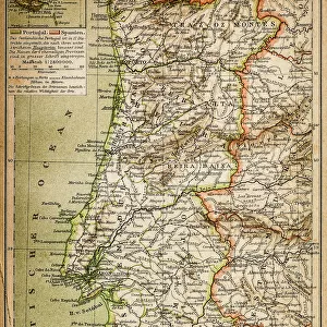
Framed Print : Topographic map of Spain and Portugal, lithograph, published in 1897


![]()
Framed Photos from Fine Art Storehouse
Topographic map of Spain and Portugal, lithograph, published in 1897
Topographic map of Spain and Portugal. Lithograph, published in 1897
Unleash your creativity and transform your space into a visual masterpiece!
ZU_09
Media ID 35843090
Andalusia Asturias Atlantic Ocean Barcelona Spain Brown Catalonia Country Geographic Area European Culture Gibraltar Iberian Peninsula Ibiza Island Lisbon Madrid Majorca Malaga Province Mediterranean Sea Murcia Peninsula Porto Portugal Portugal Portuguese Culture Pyrenees Seville Spanish Culture Topographic Map Topography Valencia Spain Zaragoza Province Ebro River
13.5"x11.5" (34x29cm) Premium Frame
Discover the rich history and geography of Spain and Portugal with our stunning Topographic Map Framed Print. This beautiful lithograph, published by ZU_09 in 1897, showcases intricate details of the topography of the Iberian Peninsula. Bring a piece of historical cartography into your home or office, and add an elegant touch to your decor. Our high-quality framed print is made to last, ensuring that the intricate lines and vibrant colors of this vintage map remain preserved for years to come.
Framed and mounted 9x7 print. Professionally handmade full timber moulded frames are finished off with framers tape and come with a hanging solution on the back. Outer dimensions are 13.5x11.5 inches (34x29cm). Quality timber frame frame moulding (20mm wide and 30mm deep) with frame colours in your choice of black, white, or raw oak and a choice of black or white card mounts. Frames have a perspex front providing a virtually unbreakable glass-like finish which is easily cleaned with a damp cloth.
Contemporary Framed and Mounted Prints - Professionally Made and Ready to Hang
Estimated Image Size (if not cropped) is 21.4cm x 21.4cm (8.4" x 8.4")
Estimated Product Size is 34cm x 29.2cm (13.4" x 11.5")
These are individually made so all sizes are approximate
Artwork printed orientated as per the preview above, with landscape (horizontal) or portrait (vertical) orientation to match the source image.
FEATURES IN THESE COLLECTIONS
> Fine Art Storehouse
> Map
> Historical Maps
> Arts
> Artists
> O
> Oceanic Oceanic
> Arts
> Landscape paintings
> Waterfall and river artworks
> River artworks
> Europe
> Portugal
> Related Images
> Europe
> Related Images
EDITORS COMMENTS
This stunning topographic map, published in 1897, offers a captivating glimpse into the geography of Spain and Portugal during the late 19th century. The intricate lithograph depicts the Iberian Peninsula in exquisite detail, with the richly textured terrain of the land and the shimmering waters of the Atlantic Ocean and Mediterranean Sea. The map highlights the major cities and provinces of Spain, including Madrid, Seville, Valencia, Barcelona, Zaragoza, Murcia, Malaga, and Catalonia, as well as Portugal's Lisbon and Porto. The Pyrenees mountain range, the Ebro River, and the Strait of Gibraltar are also clearly marked. The map's intricate topography reveals the diverse landscapes of the region, from the rolling hills of Asturias to the rugged cliffs of Majorca and Ibiza islands, and the sun-soaked coastlines of Andalusia. The map's brown and blue color palette adds to its antique charm, transporting us back in time to an era when exploration and discovery were at the forefront of human endeavor. This beautiful piece of cartographic history is a testament to the rich cultural heritage of Spain and Portugal, showcasing the unique character of each region and the natural beauty of the Iberian Peninsula. Whether you're an avid collector of historical maps, a student of European history, or simply someone who appreciates the art of cartography, this topographic map is a must-have addition to your collection.
MADE IN AUSTRALIA
Safe Shipping with 30 Day Money Back Guarantee
FREE PERSONALISATION*
We are proud to offer a range of customisation features including Personalised Captions, Color Filters and Picture Zoom Tools
SECURE PAYMENTS
We happily accept a wide range of payment options so you can pay for the things you need in the way that is most convenient for you
* Options may vary by product and licensing agreement. Zoomed Pictures can be adjusted in the Cart.