Framed Print > Europe > United Kingdom > England > London > Museums > British Library
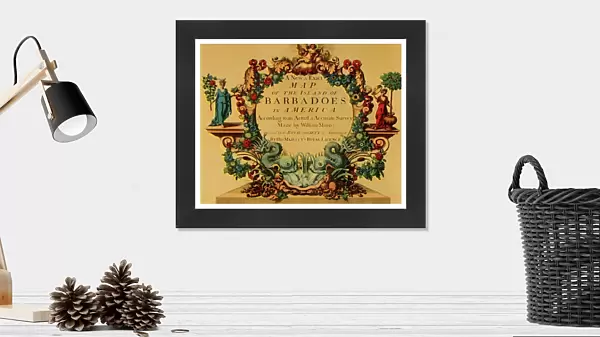
Framed Print : Cartouche on W. Mayos Map of Barbados, 1722, (1944). Creator: William Mayo
. Creator: William Mayo")

. Creator: William Mayo")

![]()
Framed Photos from Heritage Images
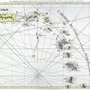
Cartouche on W. Mayos Map of Barbados, 1722, (1944). Creator: William Mayo
Cartouche on W. Mayos Map of Barbados, 1722, (1944). A New & Exact Map of the Island of Barbadoes in America. According to an Actual & Accurate Survey. Made by William Mayo; Approved by the Royal Society & Authorized by His Majestys Royal Licence. Inscription with stylised floral decoration including dolphins. Map in the Kings Topographical Collection, the first large-scale survey of the island carried out by civil engineer and cartographer William Mayo, in the British Library, London. From " British Maps and Map-Makers", by Edward Lynam. [Collins, London, 1944]
Heritage Images features heritage image collections
Media ID 19777288
© The Print Collector/Heritage Images
Barbados Britain In Pictures Cartography Cartouche Collins Dolphin Dolphins Edward Edward Lynam Inscribed Inscription Island Lynam Map Making Mapmaking Social History William Collins William Collins And Sons Graphic Design Mayo
13.5"x11.5" (34x29cm) Premium Frame
Step back in time with our stunning Framed Print from Media Storehouse's Heritage Images collection. This exquisite piece features a captivating cartouche from William Mayo's 1722 map of Barbados. The intricate design adorns the border of "A New & Exact Map of the Island of Barbadoes in America," meticulously surveyed and created in 1722, and later reproduced in 1944. Add an air of historical charm to your space with this unique, museum-quality Framed Print, perfect for history enthusiasts and cartography aficionados alike.
Framed and mounted 9x7 print. Professionally handmade full timber moulded frames are finished off with framers tape and come with a hanging solution on the back. Outer dimensions are 13.5x11.5 inches (34x29cm). Quality timber frame frame moulding (20mm wide and 30mm deep) with frame colours in your choice of black, white, or raw oak and a choice of black or white card mounts. Frames have a perspex front providing a virtually unbreakable glass-like finish which is easily cleaned with a damp cloth.
Contemporary Framed and Mounted Prints - Professionally Made and Ready to Hang
Estimated Image Size (if not cropped) is 21.4cm x 21.4cm (8.4" x 8.4")
Estimated Product Size is 34cm x 29.2cm (13.4" x 11.5")
These are individually made so all sizes are approximate
Artwork printed orientated as per the preview above, with landscape (horizontal) or portrait (vertical) orientation to match the source image.
FEATURES IN THESE COLLECTIONS
> Animals
> Aquatic
> Cetacea
> Dolphin
> Animals
> Mammals
> Muridae
> Fortior
> Arts
> Artists
> C
> William Collins
> Europe
> United Kingdom
> England
> London
> Museums
> British Library
> Europe
> United Kingdom
> England
> London
> Royalty
> Europe
> United Kingdom
> England
> Maps
> Maps and Charts
> Related Images
> North America
> Barbados
> Maps
> North America
> Barbados
> Related Images
EDITORS COMMENTS
This print showcases a remarkable cartouche found on W. Mayo's Map of Barbados from 1722, which was reproduced in 1944. Created by the skilled hands of William Mayo, a civil engineer and cartographer, this map is an invaluable piece of history housed in the Kings Topographical Collection at the British Library in London. The cartouche itself is a true work of art, featuring an inscription surrounded by stylized floral decorations that exude elegance and charm. Amongst these intricate designs are beautifully depicted dolphins, adding a touch of whimsy to the composition. Mayo's map holds great significance as it represents the first large-scale survey ever conducted on the island of Barbados. Approved by the Royal Society and authorized by His Majesty's Royal Licence, this meticulously crafted map provides an accurate depiction of Barbados based on extensive research and surveys. Edward Lynam's book "British Maps and Map-Makers" sheds light on this fascinating piece, offering insights into its historical context and importance within British cartography. The print captures not only the beauty but also serves as a reminder of how maps have played a crucial role in shaping our understanding of geography throughout different centuries. With its vibrant colors and exquisite design elements, this print transports us back to both the 18th century when Mayo created his masterpiece and to mid-20th century Britain when it was reproduced for wider appreciation. It stands as a testament to human curiosity about our world while showcasing exceptional craftsmanship that has stood the test of time.
MADE IN AUSTRALIA
Safe Shipping with 30 Day Money Back Guarantee
FREE PERSONALISATION*
We are proud to offer a range of customisation features including Personalised Captions, Color Filters and Picture Zoom Tools
SECURE PAYMENTS
We happily accept a wide range of payment options so you can pay for the things you need in the way that is most convenient for you
* Options may vary by product and licensing agreement. Zoomed Pictures can be adjusted in the Cart.