Framed Print : Brooklyn, Vol. 1, Double Page Plate No. 8;Part of Wards 6 & 12, Section 2;Map bounded
![]()

Framed Photos from Liszt Collection
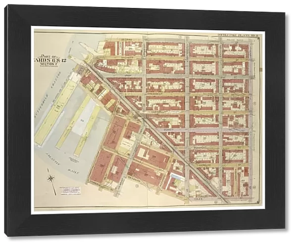
Brooklyn, Vol. 1, Double Page Plate No. 8;Part of Wards 6 & 12, Section 2;Map bounded
Brooklyn, Vol. 1, Double Page Plate No. 8; Part of Wards 6 & 12, Section 2; Map bounded by Degraw St. Henry St. Coles St. Seabring St. Van Brunt St. Commerce St.; Including Commercial Wharf Conover St. India Wharf, Hamilton Ave. Un
Liszt Collection of nineteenth-century engravings and images to browse and enjoy
Media ID 12673389
© Quint Lox Limited
Brooklyn Cartographic Degraw St Double Page Hamilton Ave Historic Map Map Bounded By Plate No 8 Vintage Map Vol 1 Henry St Section 2
21.5"x17.5" (55x44cm) Premium Frame
Add a touch of history and charm to your home decor with our Framed Prints from the Media Storehouse's Brooklyn, Vol. 1 collection. This stunning Double Page Plate No. 8 is a captivating reproduction of an original map from the Liszt Collection. Featuring a detailed depiction of part of Wards 6 & 12, Section 2 in Brooklyn, this vintage map is bounded by Degraw Street, Henry Street, Coles Street, Seabring Street, and Van Brunt Street. The intricate lines and precise cartography transport you back in time, making it a unique and intriguing conversation starter. Our Framed Prints are meticulously crafted with museum-quality materials to ensure long-lasting beauty and durability. Each print is carefully framed with a sleek, modern design that complements the historical charm of the map. Bring a piece of Brooklyn's rich history into your living space with our Framed Prints. Order yours today and add a touch of timeless elegance to your home or office.
Framed and mounted 17x12 print. Professionally handmade full timber moulded frames are finished off with framers tape and come with a hanging solution on the back. Outer dimensions are 21.5x17.5 inches (546x444mm). Quality timber frame frame moulding (20mm wide and 30mm deep) with frame colours in your choice of black, white, or raw oak and a choice of black or white card mounts. Frames have a perspex front providing a virtually unbreakable glass-like finish which is easily cleaned with a damp cloth.
Contemporary Framed and Mounted Prints - Professionally Made and Ready to Hang
Estimated Image Size (if not cropped) is 41.8cm x 41.8cm (16.5" x 16.5")
Estimated Product Size is 54.6cm x 44.4cm (21.5" x 17.5")
These are individually made so all sizes are approximate
Artwork printed orientated as per the preview above, with landscape (horizontal) or portrait (vertical) orientation to match the source image.
EDITORS COMMENTS
This vintage map print titled "Brooklyn, Vol. 1, Double Page Plate No. 8; Part of Wards 6 & 12, Section 2" takes us back in time to the bustling streets of Brooklyn in its early days. With intricate cartographic details and historic charm, this piece captures a specific section bounded by Degraw St. , Henry St. , Coles St. , Seabring St. , Van Brunt St. , Commerce St. The map encompasses various landmarks that were significant during that era, including Commercial Wharf Conover St. , India Wharf, Hamilton Ave. It offers a glimpse into the commercial activities and maritime trade that shaped this part of Brooklyn's history. As we study this artwork from the Liszt Collection, we are transported to an America long gone but not forgotten. The attention to detail and precision in mapping out every street and building is awe-inspiring. This print serves as a testament to the artistry of cartography and its ability to preserve historical moments for generations to come. Whether you're a lover of geography or simply fascinated by old maps, this piece is sure to spark curiosity about Brooklyn's past. Hang it on your wall as a conversation starter or use it as an educational tool for studying urban development over time. This vintage map print beautifully combines art and history into one captivating composition that will surely stand the test of time.
MADE IN AUSTRALIA
Safe Shipping with 30 Day Money Back Guarantee
FREE PERSONALISATION*
We are proud to offer a range of customisation features including Personalised Captions, Color Filters and Picture Zoom Tools
SECURE PAYMENTS
We happily accept a wide range of payment options so you can pay for the things you need in the way that is most convenient for you
* Options may vary by product and licensing agreement. Zoomed Pictures can be adjusted in the Cart.


