Framed Print > Europe > United Kingdom > Wales > Maps
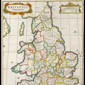
Framed Print : Map / Britain / Saxon Period


![]()
Framed Photos from Mary Evans Picture Library
Map / Britain / Saxon Period
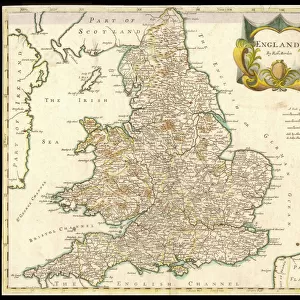
Map of England and Wales showing kingdoms of Saxon heptarchy
Mary Evans Picture Library makes available wonderful images created for people to enjoy over the centuries
Media ID 579234
© Mary Evans Picture Library 2015 - https://copyrighthub.org/s0/hub1/creation/maryevans/MaryEvansPictureID/10021575
13.5"x11.5" (34x29cm) Premium Frame
Discover the rich history of the Saxon Period in Britain with our stunning framed prints from Mary Evans Picture Library. This captivating map, titled "Map / Britain / Saxon Period," transports you back in time to the heptarchy era. Each detail, from the distinct kingdoms to the winding rivers and coastlines, is brought to life in exquisite detail. Our high-quality framed prints are meticulously crafted to preserve the authenticity and vibrancy of the original image. Add this beautiful piece to your home or office to ignite conversations and inspire a deeper appreciation for the history of Britain.
Framed and mounted 9x7 print. Professionally handmade full timber moulded frames are finished off with framers tape and come with a hanging solution on the back. Outer dimensions are 13.5x11.5 inches (34x29cm). Quality timber frame frame moulding (20mm wide and 30mm deep) with frame colours in your choice of black, white, or raw oak and a choice of black or white card mounts. Frames have a perspex front providing a virtually unbreakable glass-like finish which is easily cleaned with a damp cloth.
Contemporary Framed and Mounted Prints - Professionally Made and Ready to Hang
Estimated Image Size (if not cropped) is 21.4cm x 21.4cm (8.4" x 8.4")
Estimated Product Size is 29.2cm x 34cm (11.5" x 13.4")
These are individually made so all sizes are approximate
Artwork printed orientated as per the preview above, with landscape (horizontal) or portrait (vertical) orientation to match the source image.
FEATURES IN THESE COLLECTIONS
> Europe
> United Kingdom
> England
> Maps
> Europe
> United Kingdom
> England
> Posters
> Europe
> United Kingdom
> England
> Related Images
> Europe
> United Kingdom
> Wales
> Maps
> Europe
> United Kingdom
> Wales
> Posters
> Europe
> United Kingdom
> Wales
> Related Images
> Maps and Charts
> Early Maps
> Maps and Charts
> Related Images
> Maps and Charts
> Wales
> Mary Evans Prints Online
> Maps
EDITORS COMMENTS
This stunning print captures a detailed map of Britain during the Saxon period, showcasing the intricate kingdoms of the heptarchy. Dating back to the 6th and 8th centuries, this historical map provides a fascinating glimpse into England and Wales during this pivotal time in history.
The divisions of power among the various Saxon kingdoms are clearly delineated on this map, offering insight into the political landscape of early medieval Britain. From Mercia to Wessex, each kingdom played a crucial role in shaping the future of England as we know it today.
As you study this image, you can almost imagine yourself traveling back in time to witness firsthand the struggles and triumphs of these ancient peoples. The intricate details and vibrant colors bring this piece of history to life, allowing us to connect with our past in a tangible way.
Whether you're a history buff or simply appreciate beautiful artwork, this map is sure to captivate your imagination and spark your curiosity about Britain's rich heritage. Display it proudly in your home or office as a conversation starter and reminder of how far we've come as a nation.
MADE IN AUSTRALIA
Safe Shipping with 30 Day Money Back Guarantee
FREE PERSONALISATION*
We are proud to offer a range of customisation features including Personalised Captions, Color Filters and Picture Zoom Tools
SECURE PAYMENTS
We happily accept a wide range of payment options so you can pay for the things you need in the way that is most convenient for you
* Options may vary by product and licensing agreement. Zoomed Pictures can be adjusted in the Cart.