Framed Print > Arts > Artists > C > Samuel de Champlain
Framed Print : EXPL2A-00297


![]()
Framed Photos from North Wind
EXPL2A-00297
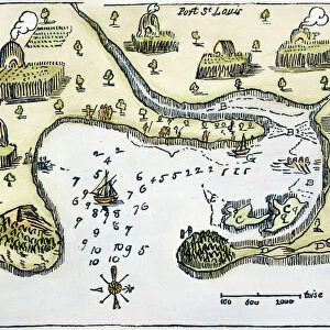
Champlains 1613 map of his settlement at Port Royal, now Annapolis Royal, Nova Scotia, Canada.
Hand-colored 19th-century woodcut reproduction of Champlains drawing
North Wind Picture Archives brings history to life with stock images and hand-colored illustrations
Media ID 5879440
© North Wind Picture Archives
1600s 17th Century Acadia Atlantic Atlantic Ocean Canada Canadian Cartography Champlain City Colonial Colonist Colony Discover Document Exploration Explore French French Canada Harbor Maritime Navigation New France New World Nova Scotia Ocean Samuel De Champlain Settlement Settler Town 1613 Annapolis Annapolis Royal Port Royal
A2 Premium Frame with A3 Poster
Discover the rich history of Annapolis Royal, Nova Scotia, Canada with our stunning Framed Print from Media Storehouse. Featuring the EXPL2A-00297 image from North Wind Picture Archives, this captivating 19th-century woodcut reproduction showcases Champlain's drawing of his settlement at Port Royal. Hand-colored to bring out the intricate details, this framed print is a beautiful addition to any home or office, transporting you back in time to the founding of this historic town. Embrace the past with this exquisite piece of art.
Premium Paradise Wooden Range A2 Premium Poster Frame (62x45cm) with A3 Poster (42x30cm) and mounted behind a white matt board to make your photo really stand out. FSC Certified and Rainforest Alliance Certified for environmental, social, and economic sustainably. High transparency tempered glass window with a smooth finished frame. Great for filling empty walls, decorating blank spaces, or creating eye-catching gallery walls. Frames arrive ready to hang. Sent with secure, protective packaging. Smooth wooden veneer mimics the real wood look and feel with ultra-durable scratch resistance tempered glass.
Contemporary Framed and Mounted Prints - Professionally Made and Ready to Hang
Estimated Image Size (if not cropped) is 40.4cm x 40.4cm (15.9" x 15.9")
Estimated Product Size is 62cm x 44.6cm (24.4" x 17.6")
These are individually made so all sizes are approximate
Artwork printed orientated as per the preview above, with landscape (horizontal) or portrait (vertical) orientation to match the source image.
FEATURES IN THESE COLLECTIONS
> Arts
> Artists
> C
> Samuel de Champlain
> Arts
> Artists
> O
> Oceanic Oceanic
> Historic
> Colonial America illustrations
> Colonial America
> Historic
> Colonial America illustrations
> Historic
> Colonial history
> Colonial art and artists
> Maps and Charts
> World
> North Wind Picture Archives
> Canadian history
> North Wind Picture Archives
> Maps
EDITORS COMMENTS
This print takes us back in time to the early 17th century, offering a glimpse into the historical settlement of Port Royal, now known as Annapolis Royal, Nova Scotia. The hand-colored woodcut reproduction showcases Samuel de Champlain's intricate map from 1613, meticulously illustrating his exploration and establishment of this colonial outpost. The image transports us to an era of maritime discovery and navigation along the Atlantic Ocean. It beautifully captures the essence of a bygone era with its vintage charm and artistic flair. As we delve into this piece of art, we are reminded of the rich history that shaped Canada's French roots. Champlain's detailed cartography provides valuable insight into the early days of European settlement in North America. This document serves as a testament to Champlain's role as both explorer and settler, shedding light on his significant contributions to Canadian history. The bustling harbor depicted in this illustration reveals a thriving community that played a vital role in New France during the 1600s. The map invites us to explore every corner, tracing our fingers over each street and building as if we were there ourselves. As we admire this remarkable piece from North Wind Picture Archives, let us appreciate not only its artistic value but also its ability to transport us through time – allowing us to discover and connect with our past while marveling at how far we have come.
MADE IN AUSTRALIA
Safe Shipping with 30 Day Money Back Guarantee
FREE PERSONALISATION*
We are proud to offer a range of customisation features including Personalised Captions, Color Filters and Picture Zoom Tools
SECURE PAYMENTS
We happily accept a wide range of payment options so you can pay for the things you need in the way that is most convenient for you
* Options may vary by product and licensing agreement. Zoomed Pictures can be adjusted in the Cart.