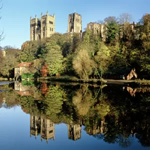
Framed Print > Arts > Landscape paintings > Waterfall and river artworks > River artworks
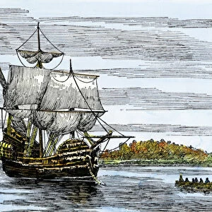
Framed Print : Dutch map of New Netherland and New England


![]()
Framed Photos from North Wind
Dutch map of New Netherland and New England
New Netherland and New England, circa 1630.
Hand-colored 19th-century woodcut reproduction of DeLaets map
North Wind Picture Archives brings history to life with stock images and hand-colored illustrations
Media ID 5880982
© North Wind Picture Archives
1600s 17th Century America Cape Cod Colonial Connecticut Discover Dutch Dutch Colony Eastern English English Colony Exploration Explore Hudson River Lake Champlain Massachusetts New Amsterdam New England New Jersey New Netherland New World New York Rhode Island 1630 Long Island
13.5"x11.5" (34x29cm) Premium Frame
Step back in time with our exquisite Framed Prints from Media Storehouse, featuring this captivating 19th-century woodcut reproduction of the Dutch map of New Netherland and New England from North Wind Picture Archives. Dating back to circa 1630, this intricately detailed hand-colored map offers a glimpse into the rich history of early American exploration. Add an element of history and culture to your home or office decor with this stunning piece, expertly framed in a timeless design that complements the map's antique charm. Order now and transport yourself to a bygone era.
Framed and mounted 9x7 print. Professionally handmade full timber moulded frames are finished off with framers tape and come with a hanging solution on the back. Outer dimensions are 13.5x11.5 inches (34x29cm). Quality timber frame frame moulding (20mm wide and 30mm deep) with frame colours in your choice of black, white, or raw oak and a choice of black or white card mounts. Frames have a perspex front providing a virtually unbreakable glass-like finish which is easily cleaned with a damp cloth.
Contemporary Framed and Mounted Prints - Professionally Made and Ready to Hang
Estimated Image Size (if not cropped) is 21.4cm x 21.4cm (8.4" x 8.4")
Estimated Product Size is 34cm x 29.2cm (13.4" x 11.5")
These are individually made so all sizes are approximate
Artwork printed orientated as per the preview above, with landscape (horizontal) or portrait (vertical) orientation to match the source image.
FEATURES IN THESE COLLECTIONS
> Arts
> Landscape paintings
> Waterfall and river artworks
> River artworks
> Europe
> United Kingdom
> England
> Lakes
> Europe
> United Kingdom
> England
> Maps
> Europe
> United Kingdom
> England
> Rivers
> Europe
> United Kingdom
> England
> York
> Historic
> Colonial America illustrations
> Colonial America
> Historic
> Colonial America illustrations
> Historic
> Colonial history
> Colonial art and artists
> North Wind Picture Archives
> Exploration
> North Wind Picture Archives
> Maps
EDITORS COMMENTS
This vintage print showcases a Dutch map of New Netherland and New England, dating back to the 17th century. Hand-colored in the 19th century, this woodcut reproduction of DeLaet's map exudes a sense of heritage and tradition. The intricate illustration takes us on an exploration through time, revealing the early colonial history of America. The map encompasses various regions, including New York, Massachusetts, Connecticut, New Jersey, Rhode Island, and parts of present-day Vermont. It highlights significant landmarks such as Long Island and Cape Cod while tracing the course of the Hudson River and Lake Champlain. Notably featured are Fort Orange (present-day Albany) and New Amsterdam (now known as Manhattan), both prominent Dutch settlements during that era. This historical artifact offers a glimpse into the complex dynamics between English colonies and their Dutch counterparts in North America. It symbolizes an era when European powers vied for control over these newly discovered lands. As we admire this remarkable piece of artistry from North Wind Picture Archives, it serves as a reminder of our rich past and how far we have come since those early days of exploration. Whether displayed in homes or educational institutions alike, this print sparks curiosity about our collective history while celebrating the beauty found within cartography's artistic expression.
MADE IN AUSTRALIA
Safe Shipping with 30 Day Money Back Guarantee
FREE PERSONALISATION*
We are proud to offer a range of customisation features including Personalised Captions, Color Filters and Picture Zoom Tools
SECURE PAYMENTS
We happily accept a wide range of payment options so you can pay for the things you need in the way that is most convenient for you
* Options may vary by product and licensing agreement. Zoomed Pictures can be adjusted in the Cart.