Framed Print > Arts > Artists > M > Sebastian Munster
Framed Print : Map of Palestine, 1588


![]()
Framed Photos from Science Photo Library
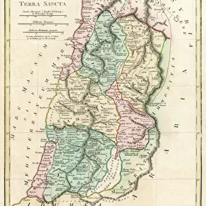
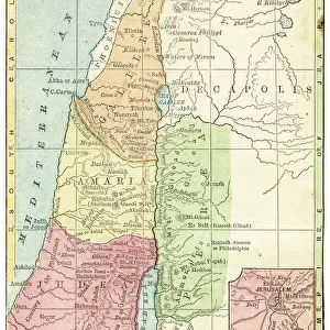
Map of Palestine, 1588
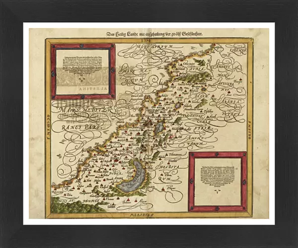
16th century map of Palestine. North is towards upper right. Published in 1588, this German map shows the geography of Palestine, centred on the area that later become the state of Israel. The inscriptions are in German, and the place names are in Latin. These include ancient names like Petra, Coele Syria and Judea. The Dead Sea is at lower centre, and the Mediterranean coast is at left. Numerous towns and villages are shown on the map. The map is by the German cartographer Sebastian Munster (1489-1552), and was published in Basel in a posthumous edition of his Cosmographia, the earliest German atlas
Science Photo Library features Science and Medical images including photos and illustrations
Media ID 1699831
© LIBRARY OF CONGRESS, GEOGRAPHY AND MAP DIVISION/SCIENCE PHOTO LIBRARY
1500s 1588 16th Century Arab Cartography Dead Sea German Israel Jewish Judea Medieval Middle Ages Middle East Palestine Cosmographia Petra Sebastian Munster
13.5"x11.5" (34x29cm) Premium Frame
Introducing the Media Storehouse Framed Print of "Map of Palestine, 1588" by Science Photo Library. This captivating piece of historical cartography takes you back to the 16th century, showcasing an intriguing representation of Palestine as it was understood during that time. The map, published in 1588, is of German origin and is centered around the area that would later become the modern-day state of Israel. With its antique charm and intricate detailing, this framed print adds an intellectual and stylish touch to any room, making it a perfect addition to your home or office decor. Bring a piece of history into your space with the Media Storehouse Framed Print of "Map of Palestine, 1588".
Framed and mounted 9x7 print. Professionally handmade full timber moulded frames are finished off with framers tape and come with a hanging solution on the back. Outer dimensions are 13.5x11.5 inches (34x29cm). Quality timber frame frame moulding (20mm wide and 30mm deep) with frame colours in your choice of black, white, or raw oak and a choice of black or white card mounts. Frames have a perspex front providing a virtually unbreakable glass-like finish which is easily cleaned with a damp cloth.
Contemporary Framed and Mounted Prints - Professionally Made and Ready to Hang
Estimated Image Size (if not cropped) is 21.4cm x 21.4cm (8.4" x 8.4")
Estimated Product Size is 34cm x 29.2cm (13.4" x 11.5")
These are individually made so all sizes are approximate
Artwork printed orientated as per the preview above, with landscape (horizontal) or portrait (vertical) orientation to match the source image.
FEATURES IN THESE COLLECTIONS
> Arts
> Art Movements
> Medieval Art
> Arts
> Artists
> M
> Sebastian Munster
> Arts
> Artists
> S
> Syrian Syrian
> Asia
> Israel
> Related Images
> Asia
> Palestine
> Related Images
> Asia
> Syria
> Related Images
> Science Photo Library
> History
EDITORS COMMENTS
This 16th-century map of Palestine, printed in 1588, offers a fascinating glimpse into the geography and history of the region. Created by renowned German cartographer Sebastian Munster, this map showcases the area that would later become the state of Israel. With its north oriented towards the upper right corner, it presents an array of ancient names like Petra, Coele Syria, and Judea. The inscriptions on this print are in German while the place names are written in Latin. The Dead Sea takes center stage at the lower part of the map, while to its left lies the picturesque Mediterranean coast. This meticulously detailed artwork also highlights numerous towns and villages scattered across Palestine. Published posthumously as part of Munster's Cosmographia atlas in Basel, Switzerland, this historic piece provides invaluable insights into medieval cartography during a time when accurate maps were scarce. It serves as a testament to Munster's expertise and dedication to his craft. As we explore this remarkable snapshot from centuries past, we can appreciate both its artistic beauty and historical significance. From its depiction of ancient landmarks to its portrayal of regional boundaries long before modern political divisions emerged – this print is not only a treasure for geographers but also for those intrigued by Middle Eastern history and culture.
MADE IN AUSTRALIA
Safe Shipping with 30 Day Money Back Guarantee
FREE PERSONALISATION*
We are proud to offer a range of customisation features including Personalised Captions, Color Filters and Picture Zoom Tools
SECURE PAYMENTS
We happily accept a wide range of payment options so you can pay for the things you need in the way that is most convenient for you
* Options may vary by product and licensing agreement. Zoomed Pictures can be adjusted in the Cart.