Framed Print > Europe > United Kingdom > England > London > Sights > British Museum
Framed Print : Map of Mesopotamia
![]()

Framed Photos from Science Photo Library
Map of Mesopotamia
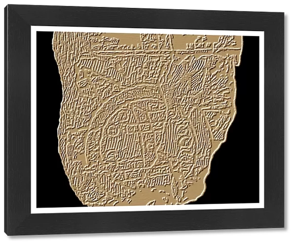
Map of Mesopotamia. Computer artwork of markings on a stone tablet showing a map of Mesopotamia. The stone tablet dates from between 700 and 500 BC and is from Sippar in southern Iraq. The ancient city of Babylon is the rectangle located at the centre of the map. Cuneiform script elsewhere on the tablet also mentions Assyria and Elam. The Mesopotamian world is surrounded by a circular waterway labelled salt-sea. Triangular regions, or islands, beyond the sea were thought to be home to mythical creatures. Mesopotamia refers to a region between the Tigris and Euphrates rivers in what is now Iraq. The stone tablet is kept in the British Museum
Science Photo Library features Science and Medical images including photos and illustrations
Media ID 6350463
© SHEILA TERRY/SCIENCE PHOTO LIBRARY
Ancient Anthropology Antiquity Archaeology Babylon Babylonian Cartography Classical Cuneiform Earth Science Graphic Inscription Iraq Island Islands Land Mapping Maps Mesopotamia Middle East Mythological Mythology Region Regions Sciences Assyria Cartographical Computer Artwork Elam Iraqi Sippar Stone Tablet
13.5"x11.5" (34x29cm) Premium Frame
Discover the rich history of Mesopotamia with our stunning Framed Prints from Media Storehouse. This captivating Map of Mesopotamia, sourced from Science Photo Library, showcases intricate markings on a ancient stone tablet dating back to between 700 and 500 BC from Sippar in southern Iraq. Bring the mysteries of Mesopotamian civilization into your home or office with this beautiful, high-quality framed print. A perfect addition to any space for history enthusiasts, educators, or those who appreciate the art and culture of ancient civilizations.
Framed and mounted 9x7 print. Professionally handmade full timber moulded frames are finished off with framers tape and come with a hanging solution on the back. Outer dimensions are 13.5x11.5 inches (34x29cm). Quality timber frame frame moulding (20mm wide and 30mm deep) with frame colours in your choice of black, white, or raw oak and a choice of black or white card mounts. Frames have a perspex front providing a virtually unbreakable glass-like finish which is easily cleaned with a damp cloth.
Contemporary Framed and Mounted Prints - Professionally Made and Ready to Hang
Estimated Image Size (if not cropped) is 21.4cm x 21.4cm (8.4" x 8.4")
Estimated Product Size is 34cm x 29.2cm (13.4" x 11.5")
These are individually made so all sizes are approximate
Artwork printed orientated as per the preview above, with landscape (horizontal) or portrait (vertical) orientation to match the source image.
FEATURES IN THESE COLLECTIONS
> Arts
> Artists
> B
> Babylonian Babylonian
> Arts
> Landscape paintings
> Waterfall and river artworks
> River artworks
> Asia
> Iraq
> Related Images
> Asia
> Related Images
> Europe
> France
> Canton
> Landes
> Europe
> United Kingdom
> England
> London
> Sights
> British Museum
> Historic
> Ancient civilizations
> Mesopotamia
> Ancient Mesopotamian art
> Historic
> Ancient civilizations
> Mesopotamia
> Ancient Mesopotamian cities
> Historic
> Ancient civilizations
> Mesopotamia
> Cuneiform tablets
EDITORS COMMENTS
This print showcases a remarkable computer artwork of markings on a stone tablet, revealing an ancient map of Mesopotamia. Dating back to the period between 700 and 500 BC, this historical artifact was discovered in Sippar, located in southern Iraq. At the heart of this intricate map lies the renowned city of Babylon, depicted as a rectangular shape. The tablet's cuneiform script also references other prominent regions such as Assyria and Elam. Surrounding the Mesopotamian world is a circular waterway labeled as the salt-sea. Beyond this vast expanse lie triangular regions or islands that were believed to be inhabited by mythical creatures, adding an element of mystique to this ancient depiction. Mesopotamia itself refers to the region situated between the Tigris and Euphrates rivers in what is now modern-day Iraq. Preserved within the esteemed British Museum, this stone tablet offers invaluable insights into classical geography and serves as a testament to our understanding of antiquity. With its rich history and cultural significance, this image not only appeals to archaeology enthusiasts but also captivates those interested in mythology, anthropology, cartography, and earth sciences. It allows us to delve into an era long gone while marveling at humanity's early attempts at mapping their surroundings.
MADE IN AUSTRALIA
Safe Shipping with 30 Day Money Back Guarantee
FREE PERSONALISATION*
We are proud to offer a range of customisation features including Personalised Captions, Color Filters and Picture Zoom Tools
SECURE PAYMENTS
We happily accept a wide range of payment options so you can pay for the things you need in the way that is most convenient for you
* Options may vary by product and licensing agreement. Zoomed Pictures can be adjusted in the Cart.


