Framed Print > Europe > United Kingdom > England > Yorkshire > Stannington
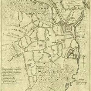
Framed Print : A map of Barley Croft and The Dukes land, Stannington, 1752


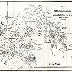
![]()
Framed Photos from Sheffield City Archives
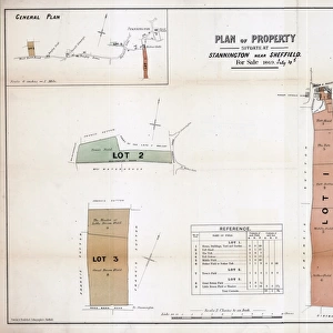
A map of Barley Croft and The Dukes land, Stannington, 1752
Scale 2 chains : 1 inch [40 inches : 1 mile]
Surveyor: William Fairbank II.
Another proposed exchange between the Duke of Norfolk and Mrs Bamforth; acreages and some field names given on the map and acreages of exchanges listed; boundaries and border coloured.
From an original at Sheffield Libraries: arc03003
Sheffield City Archives and Local Studies Library has an unrivalled collection of images of Sheffield, England
Media ID 19225917
© Sheffield City Council - All Rights Reserved
Sheffield Stannington Yorkshire
A2 Premium Frame with A3 Poster
Step back in time with our exquisite Framed Print from Media Storehouse's historical collection. This beautifully preserved map, dating back to 1752, showcases the Barley Croft and The Dukes land in Stannington. Surveied by William Fairbank II, this intricately detailed map offers a glimpse into the past, featuring proposed exchanges between the Duke of Norfolk and Mrs Bamforth, as well as acreages and field names. Bring a piece of Sheffield's rich history into your home and transport yourself back in time with this stunning, framed antique print.
Premium Paradise Wooden Range A2 Premium Poster Frame (62x45cm) with A3 Poster (42x30cm) and mounted behind a white matt board to make your photo really stand out. FSC Certified and Rainforest Alliance Certified for environmental, social, and economic sustainably. High transparency tempered glass window with a smooth finished frame. Great for filling empty walls, decorating blank spaces, or creating eye-catching gallery walls. Frames arrive ready to hang. Sent with secure, protective packaging. Smooth wooden veneer mimics the real wood look and feel with ultra-durable scratch resistance tempered glass.
Contemporary Framed and Mounted Prints - Professionally Made and Ready to Hang
Estimated Image Size (if not cropped) is 40.4cm x 40.4cm (15.9" x 15.9")
Estimated Product Size is 44.6cm x 62cm (17.6" x 24.4")
These are individually made so all sizes are approximate
Artwork printed orientated as per the preview above, with landscape (horizontal) or portrait (vertical) orientation to match the source image.
FEATURES IN THESE COLLECTIONS
> Europe
> France
> Canton
> Landes
> Europe
> United Kingdom
> England
> Norfolk
> Related Images
> Europe
> United Kingdom
> England
> Yorkshire
> Related Images
> Europe
> United Kingdom
> England
> Yorkshire
> Sheffield
> Europe
> United Kingdom
> England
> Yorkshire
> Stannington
> Maps and Charts
> Related Images
> Sheffield City Archives
> Maps and Plans
> Maps of Stannington
EDITORS COMMENTS
This print takes us back in time to the year 1752, offering a glimpse into the intricate details of Barley Croft and The Dukes land in Stannington, Yorkshire. Surveyed by the skilled William Fairbank II, this map showcases an intriguing proposed exchange between two prominent figures of that era - the Duke of Norfolk and Mrs Bamforth. The map itself is meticulously crafted with a scale of 2 chains to 1 inch, providing an accurate representation of the area's landscape. A fascinating aspect lies in its inclusion of acreages and field names, allowing us to delve deeper into the historical significance attached to each plot. Additionally, detailed listings provide information on exchanged acreages while boundaries and borders are thoughtfully colored for clarity. Preserved as part of Sheffield Libraries' collection (arc03003), this remarkable piece from Sheffield City Archives offers a unique opportunity to explore the rich history embedded within these lands. It serves as a testament to both the expertise of surveyor William Fairbank II and his dedication towards documenting such exchanges during that period. As we admire this photo print, it is important to note that it should not be used for commercial purposes. Instead, let us appreciate its value as a window into our past - one that sheds light on significant land transactions and paints a vivid picture of life in Stannington over two centuries ago.
MADE IN AUSTRALIA
Safe Shipping with 30 Day Money Back Guarantee
FREE PERSONALISATION*
We are proud to offer a range of customisation features including Personalised Captions, Color Filters and Picture Zoom Tools
SECURE PAYMENTS
We happily accept a wide range of payment options so you can pay for the things you need in the way that is most convenient for you
* Options may vary by product and licensing agreement. Zoomed Pictures can be adjusted in the Cart.
![A map of Wm. Carrs Farm at Stanington [Stannington], 1747](/sq/716/map-wm-carrs-farm-stanington-stannington-1747-19192400.jpg.webp)

![A survey of a parcel of Land called Platts... [Platts Farm, Ughill], 1728](/sq/716/survey-parcel-land-called-platts-19225923.jpg.webp)

![Maps of Several Parcels of Land proposed to be exchanged, Bradfield, [c. 1750 - 1760]](/sq/716/maps-parcels-land-proposed-exchanged-bradfield-19192402.jpg.webp)