Framed Print > Sheffield City Archives > Maps and Plans > Sheffield OS maps
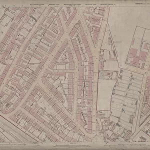
Framed Print : Ordnance Survey Map, Pitsmoor area of Sheffield, 1889 (Yorkshire sheet 294. 4. 16)
")
")

![]()
Framed Photos from Sheffield City Archives
Ordnance Survey Map, Pitsmoor area of Sheffield, 1889 (Yorkshire sheet 294. 4. 16)
This map features
Top left: n/a [blank]
Top right: Pitsmoor Road, Nottingham Street, Forton Lodge, Throstle Grove, Vicarage [Christ Church Pitsmoor], Wood Fold, Woodside House, Brittain Villas, Great Rocks Villas
Christ Church Road, Christ Church [Pitsmoor], Pilgrim Street.
Bottom left: Rutland Road, [Woodside Board] School (Boys)
Playground, Woodside Lane, Birley Street, Mission Hall
Bottom right: Woodside Lane, Mission Hall, Pitsmoor Road
Nottingham Cliff, Nottingham Street, Wood Fold, [Burngreave] Congregational Church, Sunday School, Haddon Terrace, Haywood Road, Fowler Street, [Nottingham Cliff] Recreation Ground, Rising Street.
Dimensions of original 77 x 102 cm.
Scale 10.56 feet : 1 mile [1:500].
From an original at Sheffield Libraries: q00039 (sheet 294.4.16)
Sheffield City Archives and Local Studies Library has an unrivalled collection of images of Sheffield, England
Media ID 24104143
© Sheffield City Council - All Rights Reserved
Os Maps Pitsmoor Sheffield Yorkshire
A2 Premium Frame with A3 Poster
Step back in time with our vintage Ordnance Survey Framed Print from Sheffield City Archives. This beautiful piece features the Pitsmoor area of Sheffield as it appeared in 1889, as depicted on Yorkshire sheet 294.4.16. Discover the historic landmarks of Pitsmoor Road, Nottingham Street, Forton Lodge, Throstle Grove, Vicarage [Christ Church Pitsmoor], Wood Fold, Woodside House, and Brittain Villas, all beautifully preserved in this intricately detailed map. Add a touch of history and character to your home or office with this unique and captivating framed print from Media Storehouse.
Premium Paradise Wooden Range A2 Premium Poster Frame (62x45cm) with A3 Poster (42x30cm) and mounted behind a white matt board to make your photo really stand out. FSC Certified and Rainforest Alliance Certified for environmental, social, and economic sustainably. High transparency tempered glass window with a smooth finished frame. Great for filling empty walls, decorating blank spaces, or creating eye-catching gallery walls. Frames arrive ready to hang. Sent with secure, protective packaging. Smooth wooden veneer mimics the real wood look and feel with ultra-durable scratch resistance tempered glass.
Contemporary Framed and Mounted Prints - Professionally Made and Ready to Hang
Estimated Image Size (if not cropped) is 40.4cm x 40.4cm (15.9" x 15.9")
Estimated Product Size is 62cm x 44.6cm (24.4" x 17.6")
These are individually made so all sizes are approximate
Artwork printed orientated as per the preview above, with landscape (horizontal) or portrait (vertical) orientation to match the source image.
EDITORS COMMENTS
This print showcases an Ordnance Survey Map of the Pitsmoor area in Sheffield, dating back to 1889. The map, known as Yorkshire sheet 294.4.16, provides a fascinating glimpse into the past and offers valuable insights into the historical landscape of this vibrant city. The top left section of the map is unfortunately blank or incomplete, leaving room for speculation about what might have been there during that time. Moving to the top right corner, notable landmarks such as Pitsmoor Road, Nottingham Street, Forton Lodge, Throstle Grove, Vicarage (Christ Church Pitsmoor), Wood Fold, Woodside House, Brittain Villas and Great Rocks Villas are clearly marked. Continuing our exploration towards Christ Church Road and Pilgrim Street on the upper-right side reveals further details about this bustling neighborhood. Meanwhile, on the bottom left portion of the map lies Rutland Road along with Woodside Board School (Boys) and its playground. Birley Street and Mission Hall can also be found nearby. Finally reaching the bottom right corner unveils additional points of interest including Nottingham Cliff and Nottingham Street alongside Burngreave Congregational Church and Sunday School. Haddon Terrace, Haywood Road, Fowler Street, and Rising street are also featured here along with [Nottingham Cliff] Recreation Ground. Measuring at an impressive size of 77 x 102 cm. , this original map presents a scale ratio of 10.56 feet :1
MADE IN AUSTRALIA
Safe Shipping with 30 Day Money Back Guarantee
FREE PERSONALISATION*
We are proud to offer a range of customisation features including Personalised Captions, Color Filters and Picture Zoom Tools
SECURE PAYMENTS
We happily accept a wide range of payment options so you can pay for the things you need in the way that is most convenient for you
* Options may vary by product and licensing agreement. Zoomed Pictures can be adjusted in the Cart.