Home > North America > Canada > Lakes > Lake Erie
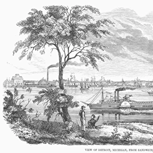
DETROIT RIVER, 1812. Map of Detroit River, the strait between Lake St. Clair and Lake Erie

![]()
Wall Art and Photo Gifts from Granger
DETROIT RIVER, 1812. Map of Detroit River, the strait between Lake St. Clair and Lake Erie
DETROIT RIVER, 1812.
Map of Detroit River, the strait between Lake St. Clair and Lake Erie, as it looked at the time of the War of 1812. Wood engraving, American, 1868
Granger holds millions of images spanning more than 25,000 years of world history, from before the Stone Age to the dawn of the Space Age
Media ID 12227208
1812 Canada Detroit Fort Detroit Lake Lake Erie Michigan Midwest Territory United States
FEATURES IN THESE COLLECTIONS
> Arts
> Landscape paintings
> Waterfall and river artworks
> River artworks
> Granger Art on Demand
> American History
> Maps and Charts
> Early Maps
> North America
> Canada
> Lakes
> Lake Erie
> North America
> Canada
> Maps
> North America
> United States of America
> Michigan
> Detroit
DETROIT RIVER, 1812 - A Glimpse into the Past
EDITORS COMMENTS
. This print takes us back to the year 1812, offering a fascinating glimpse of the Detroit River during the historic War of 1812. The wood engraving, created by an American artist in 1868, beautifully captures this significant strait that connects Lake St. Clair and Lake Erie. As we delve into this artwork from Granger Art on Demand's Carousel Collection, we are transported to a time when Michigan was still a territory and not yet part of the United States. The map showcases Fort Detroit standing proudly along the riverbanks as it played a crucial role in defending American interests against British forces during this tumultuous period. The intricate details within this engraving allow us to appreciate how much has changed over two centuries. We can almost feel ourselves stepping back in time as we observe every contour of land and water meticulously depicted by The Granger Collection. This historical artifact serves as a reminder of our nation's rich past and highlights the importance of understanding our roots. It invites us to reflect upon how far we have come since those early days in America's Midwest region while also acknowledging the struggles faced by those who came before us. Whether you are an avid history enthusiast or simply captivated by art that tells stories, "DETROIT RIVER, 1812" is sure to ignite your imagination and transport you to an era long gone but forever preserved through these remarkable engravings
MADE IN AUSTRALIA
Safe Shipping with 30 Day Money Back Guarantee
FREE PERSONALISATION*
We are proud to offer a range of customisation features including Personalised Captions, Color Filters and Picture Zoom Tools
SECURE PAYMENTS
We happily accept a wide range of payment options so you can pay for the things you need in the way that is most convenient for you
* Options may vary by product and licensing agreement. Zoomed Pictures can be adjusted in the Cart.