Home > Europe > United Kingdom > Scotland > Posters
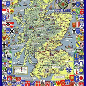
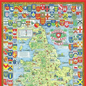
Poster, Map of Royal Britain

![]()
Wall Art and Photo Gifts from Mary Evans Picture Library
Poster, Map of Royal Britain
Poster, Map of Royal Britain.
1957
Mary Evans Picture Library makes available wonderful images created for people to enjoy over the centuries
Media ID 14412824
© Mary Evans Picture Library/Onslow Auctions Limited
FEATURES IN THESE COLLECTIONS
> Europe
> Republic of Ireland
> Maps
> Europe
> United Kingdom
> England
> Maps
> Europe
> United Kingdom
> England
> Posters
> Europe
> United Kingdom
> Maps
> Europe
> United Kingdom
> Scotland
> Maps
> Europe
> United Kingdom
> Scotland
> Posters
> Europe
> United Kingdom
> Wales
> Maps
> Europe
> United Kingdom
> Wales
> Posters
EDITORS COMMENTS
This vibrant and intricately detailed poster, titled "Map of Royal Britain," dates back to 1957 and is a captivating representation of the coats of arms of the monarchs and principalities of England, Wales, Scotland, and Ireland during the 16th through 19th centuries. The map, which is richly colored and adorned with ornate borders, serves as a visual testament to the rich history and complex lineage of the British monarchy. The map is divided into four distinct sections, each representing one of the constituent parts of the United Kingdom. In the English section, the coats of arms of the monarchs from Henry II to Elizabeth II are depicted, while in the Welsh section, the arms of the Princes of Wales and the various Welsh earls and barons are displayed. Scotland's section features the arms of the Scottish monarchs from Malcolm III to Elizabeth II, as well as those of the various Scottish earls and barons. Lastly, the Irish section showcases the arms of the monarchs of Ireland from Henry II to George V, along with those of the various Irish earls and barons. This poster, which measures approximately 23 x 30 inches (58 x 76 cm), is a fascinating historical artifact that provides a visual representation of the complex and interconnected history of the British monarchy. It is a must-have for anyone with an interest in British history, heraldry, or cartography, and is a beautiful and intriguing addition to any home or office decor. The poster, which is in good condition, was originally sold by Onslow Auctions Limited through Mary Evans Prints Online.
MADE IN AUSTRALIA
Safe Shipping with 30 Day Money Back Guarantee
FREE PERSONALISATION*
We are proud to offer a range of customisation features including Personalised Captions, Color Filters and Picture Zoom Tools
SECURE PAYMENTS
We happily accept a wide range of payment options so you can pay for the things you need in the way that is most convenient for you
* Options may vary by product and licensing agreement. Zoomed Pictures can be adjusted in the Cart.