Home > Europe > United Kingdom > England > Maps
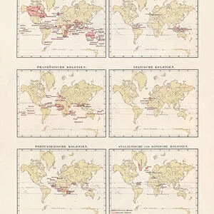
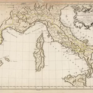
WORLD MAP: COLONIES. World map showing the colonial possessions of England, France

![]()
Wall Art and Photo Gifts from Granger
WORLD MAP: COLONIES. World map showing the colonial possessions of England, France
WORLD MAP: COLONIES.
World map showing the colonial possessions of England, France, Portugal, Spain, and Holland, by Adolph von Steinwehr, late 19th century
Granger holds millions of images spanning more than 25,000 years of world history, from before the Stone Age to the dawn of the Space Age
Media ID 12321014
Adolph British Empire Colonialism Colony World
FEATURES IN THESE COLLECTIONS
> Arts
> Landscape paintings
> Waterfall and river artworks
> River artworks
> Europe
> United Kingdom
> England
> Maps
> Europe
> United Kingdom
> England
> Rivers
> Granger Art on Demand
> Maps
> Maps and Charts
> British Empire Maps
EDITORS COMMENTS
This print, titled "WORLD MAP: COLONIES" takes us back to the late 19th century and offers a visual representation of the colonial possessions held by England, France, Portugal, Spain, and Holland. Created by Adolph von Steinwehr, this meticulously detailed world map showcases the vast empires that once spanned across continents. As we delve into this historical masterpiece, our eyes are drawn to the intricate river systems that crisscross various regions. These rivers not only served as vital transportation routes but also played a significant role in shaping the development of these colonies. The print serves as a reminder of an era marked by exploration and conquest when nations sought to expand their influence beyond their borders. It highlights how European powers competed for dominance over distant lands and peoples during an age defined by colonialism. Adolph von Steinwehr's artistic talent shines through in his precise cartographic skills. His attention to detail allows us to appreciate both the scale of these empires and their impact on global history. This remarkable piece from Granger Art on Demand invites us to reflect upon the complexities of colonization while offering a glimpse into a time when boundaries were redrawn through imperial ambitions. It serves as a testament to human curiosity and ambition – driving forces that have shaped our world throughout history.
MADE IN AUSTRALIA
Safe Shipping with 30 Day Money Back Guarantee
FREE PERSONALISATION*
We are proud to offer a range of customisation features including Personalised Captions, Color Filters and Picture Zoom Tools
SECURE PAYMENTS
We happily accept a wide range of payment options so you can pay for the things you need in the way that is most convenient for you
* Options may vary by product and licensing agreement. Zoomed Pictures can be adjusted in the Cart.