Jigsaw Puzzle > Europe > United Kingdom > England > Maps
Jigsaw Puzzle : WORLD MAP: COLONIES. World map showing the colonial possessions of England, France


![]()
Jigsaw Puzzles from Granger
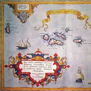
WORLD MAP: COLONIES. World map showing the colonial possessions of England, France
WORLD MAP: COLONIES.
World map showing the colonial possessions of England, France, Portugal, Spain, and Holland, by Adolph von Steinwehr, late 19th century
Granger holds millions of images spanning more than 25,000 years of world history, from before the Stone Age to the dawn of the Space Age
Media ID 12321014
Adolph British Empire Colonialism Colony World
Jigsaw Puzzle (500 Pieces)
Discover the rich history of colonial expansion with our stunning jigsaw puzzle from Media Storehouse. Featuring a captivating world map by Adolph von Steinwehr, this puzzle depicts the colonial possessions of England, France, Portugal, Spain, and Holland during the 15th to 17th centuries. Immerse yourself in the intricate details of this intriguing puzzle, perfect for history enthusiasts, puzzle collectors, or anyone seeking a challenging and educational pastime. Engage in a captivating journey through time as you piece together this beautiful and informative puzzle.
500 piece puzzles are custom made in Australia and hand-finished on 100% recycled 1.6mm thick laminated puzzle boards. There is a level of repetition in jigsaw shapes with each matching piece away from its pair. The completed puzzle measures 40x51cm and is delivered packaged in an attractive presentation box specially designed to fit most mail slots with a unique magnetic lid
Jigsaw Puzzles are an ideal gift for any occasion
Estimated Product Size is 50.7cm x 40.3cm (20" x 15.9")
These are individually made so all sizes are approximate
Artwork printed orientated as per the preview above, with landscape (horizontal) or portrait (vertical) orientation to match the source image.
FEATURES IN THESE COLLECTIONS
> Granger Art on Demand
> Maps
> Europe
> Portugal
> Related Images
> Europe
> United Kingdom
> England
> Maps
> Europe
> United Kingdom
> England
> Rivers
EDITORS COMMENTS
This print, titled "WORLD MAP: COLONIES" takes us back to the late 19th century and offers a visual representation of the colonial possessions held by England, France, Portugal, Spain, and Holland. Created by Adolph von Steinwehr, this meticulously detailed world map showcases the vast empires that once spanned across continents. As we delve into this historical masterpiece, our eyes are drawn to the intricate river systems that crisscross various regions. These rivers not only served as vital transportation routes but also played a significant role in shaping the development of these colonies. The print serves as a reminder of an era marked by exploration and conquest when nations sought to expand their influence beyond their borders. It highlights how European powers competed for dominance over distant lands and peoples during an age defined by colonialism. Adolph von Steinwehr's artistic talent shines through in his precise cartographic skills. His attention to detail allows us to appreciate both the scale of these empires and their impact on global history. This remarkable piece from Granger Art on Demand invites us to reflect upon the complexities of colonization while offering a glimpse into a time when boundaries were redrawn through imperial ambitions. It serves as a testament to human curiosity and ambition – driving forces that have shaped our world throughout history.
MADE IN AUSTRALIA
Safe Shipping with 30 Day Money Back Guarantee
FREE PERSONALISATION*
We are proud to offer a range of customisation features including Personalised Captions, Color Filters and Picture Zoom Tools
SECURE PAYMENTS
We happily accept a wide range of payment options so you can pay for the things you need in the way that is most convenient for you
* Options may vary by product and licensing agreement. Zoomed Pictures can be adjusted in the Cart.