Greetings Card > Oceania > Australia > Maps
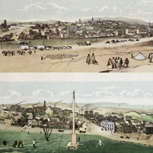
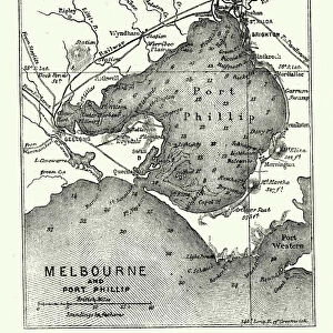
Greetings Card : Map of Melbourne and Port Phillip, Australia, 19th Century


![]()
Cards from Australian Views
Map of Melbourne and Port Phillip, Australia, 19th Century
Vintage engraving of Map of Melbourne and Port Phillip, Australia, 19th Century
Unveiling the Splendour of Australia through Exquisite Artwork
duncan1890
1130796496
Media ID 28761191
© of Duncan P Walker
1880 1889 19th Century Antique Archival Black And White Cartography Engraving Equipment History Illustration Melbourne Australia Oceania Old Fashioned Styles The Past Victorian Style Woodcut Graphic Print Navigational Equipment Retro Style Victoria Australia
Greetings Card (7"x5")
Step back in time with our exquisite range of vintage greeting cards from Media Storehouse. This particular design features an enchanting map of Melbourne and Port Phillip, Australia, as it appeared in the 19th century. Meticulously reproduced from the original engraving by duncan1890 from the Australian Views collection, this card is a delightful blend of history and art. Perfect for those who appreciate the charm of bygone eras, this card is sure to add a touch of elegance to your message. Order yours today and transport your recipient on a journey through time.
Folded Greeting Cards (12.5x17.5 cm) have a laminate finish and are supplied with an envelope. The front and inside can be personalised with text in a selection of fonts, layouts and colours.
Greetings Cards suitable for Birthdays, Weddings, Anniversaries, Graduations, Thank You and much more
Estimated Product Size is 17.5cm x 12.5cm (6.9" x 4.9")
These are individually made so all sizes are approximate
Artwork printed orientated as per the preview above, with landscape (horizontal) or portrait (vertical) orientation to match the source image.
FEATURES IN THESE COLLECTIONS
> Australian Views
> Australia's Rich History
> Historic
> Historical fashion trends
> Victorian fashion trends
> Historic
> Victorian era fashion
> Maps and Charts
> Related Images
> Oceania
> Australia
> Melbourne
> Oceania
> Australia
> Related Images
EDITORS COMMENTS
This vintage engraving of the Map of Melbourne and Port Phillip, Australia takes us back to the 19th century, offering a glimpse into the rich history and development of this vibrant city. The black and white woodcut illustration showcases intricate cartography skills that were prevalent during that era. The map itself is a testament to the navigational equipment used at the time, highlighting how seafarers relied on such detailed illustrations for safe passage. It serves as an archival piece, capturing a snapshot of Melbourne's past in its old-fashioned retro style. As we delve into this graphic print, we are transported to Victorian-era Australia. The meticulous attention to detail reveals various styles employed by cartographers during this period. This particular map was created between 1880-1889, making it an invaluable historical artifact. Melbourne's prominence as a major city in Victoria is evident through its depiction on this map. Every street corner and landmark is meticulously outlined, providing insight into how urban planning evolved over time. Duncan1890 has skillfully captured the essence of Melbourne's heritage with this antique print. Whether you're an avid historian or simply appreciate artistry from days gone by, this image offers a fascinating window into Australia's past.
MADE IN AUSTRALIA
Safe Shipping with 30 Day Money Back Guarantee
FREE PERSONALISATION*
We are proud to offer a range of customisation features including Personalised Captions, Color Filters and Picture Zoom Tools
SECURE PAYMENTS
We happily accept a wide range of payment options so you can pay for the things you need in the way that is most convenient for you
* Options may vary by product and licensing agreement. Zoomed Pictures can be adjusted in the Cart.