Greetings Card > North America > Grenada > Maps
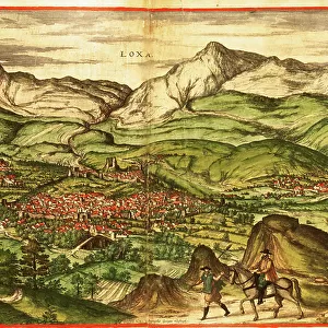
Greetings Card : Map Of Grenada, New Andalucia And Guyana Circa. 1760. From "Atlas De Toutes Les Parties Connues Du Globe Terrestre "By Cartographer Rigobert Bonne. Published Geneva Circa. 1760


![]()
Cards from Design Pics
Map Of Grenada, New Andalucia And Guyana Circa. 1760. From "Atlas De Toutes Les Parties Connues Du Globe Terrestre "By Cartographer Rigobert Bonne. Published Geneva Circa. 1760
Map Of Grenada, New Andalucia And Guyana Circa.1760. From " Atlas De Toutes Les Parties Connues Du Globe Terrestre " By Cartographer Rigobert Bonne. Published Geneva Circa. 1760
Design Pics offers Distinctively Different Imagery representing over 1,500 contributors
Media ID 18186420
© Ken Welsh / Design Pics
Andalucia Cartography Geography Grenada Mapmaking Plate Guyana
Greetings Card (7"x5")
Travel back in time with our vintage greeting cards from the Media Storehouse collection. This exquisite design features a captivating map of Grenada, New Andalucia, and Guyana, circa 1760, taken from the "Atlas De Toutes Les Parties Connues Du Globe Terrestre" by renowned cartographer Rigobert Bonne. Published in Geneva around 1760, this antique map showcases intricate detail and historical accuracy. Perfect for the history buff or travel enthusiast in your life, our vintage greeting cards make a unique and thoughtful gift. Let the adventure begin with a journey through time!
Folded Greeting Cards (12.5x17.5 cm) have a laminate finish and are supplied with an envelope. The front and inside can be personalised with text in a selection of fonts, layouts and colours.
Greetings Cards suitable for Birthdays, Weddings, Anniversaries, Graduations, Thank You and much more
Estimated Product Size is 12.5cm x 17.5cm (4.9" x 6.9")
These are individually made so all sizes are approximate
Artwork printed orientated as per the preview above, with landscape (horizontal) or portrait (vertical) orientation to match the source image.
FEATURES IN THESE COLLECTIONS
> Maps and Charts
> Related Images
> North America
> Grenada
> Maps
> North America
> Grenada
> Related Images
> South America
> Guyana
> Maps
> South America
> Guyana
> Related Images
EDITORS COMMENTS
This print showcases a historical map of Grenada, New Andalucia, and Guyana circa 1760. Created by the renowned cartographer Rigobert Bonne for his esteemed work "Atlas De Toutes Les Parties Connues Du Globe Terrestre" this map offers a fascinating glimpse into the geography and exploration of these regions during that era. The intricate details and vibrant colors of this engraving bring to life the rich history and significance of these territories. From the lush landscapes to the meandering rivers, every element is meticulously depicted with precision and artistry. As we delve into this remarkable piece of cartography, we are transported back in time to an age when mapping was not only a scientific endeavor but also an artistic expression. The horizontal layout allows us to appreciate the vastness of these lands while marveling at their unique features. This print serves as a testament to human curiosity and our relentless quest for knowledge about our planet's diverse corners. It reminds us that maps are not merely tools for navigation; they are windows into different cultures, histories, and civilizations. Whether you're an avid collector or simply fascinated by historical artifacts, this stunning image will undoubtedly captivate your imagination. Display it proudly in your home or office as a conversation starter or as a reminder of how far we've come in understanding our world's wonders.
MADE IN AUSTRALIA
Safe Shipping with 30 Day Money Back Guarantee
FREE PERSONALISATION*
We are proud to offer a range of customisation features including Personalised Captions, Color Filters and Picture Zoom Tools
SECURE PAYMENTS
We happily accept a wide range of payment options so you can pay for the things you need in the way that is most convenient for you
* Options may vary by product and licensing agreement. Zoomed Pictures can be adjusted in the Cart.