Greetings Card > Arts > Artists > O > Oceanic Oceanic
Greetings Card : Map of the Indian Ocean


![]()
Cards from Heritage Images
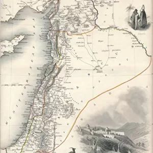
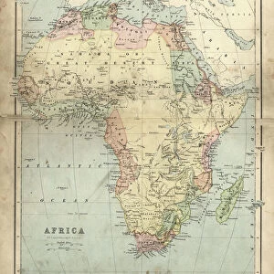
Map of the Indian Ocean
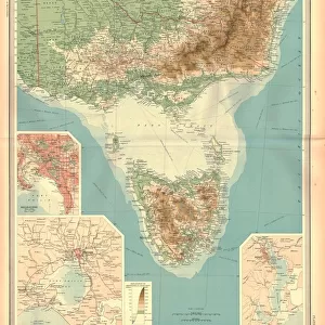
Map of the Indian Ocean. Map showing the Indian subcontinent, East Africa, the Arabian peninsula, Indo-China and Western Australia. Plate 54 from The Times Atlas
Heritage Images features heritage image collections
Media ID 15464866
© The Print Collector / Heritage-Images
Australia Cartography Coastline East Africa Indian Ocean Indochina Madagascar Map Making Oceania Saudi Arabia
Greetings Card (7"x5")
Discover the wonders of the Indian Ocean with our exquisite range of greeting cards from Media Storehouse. Featuring a captivating image of The Times Atlas Map (Plate 54), this card showcases the breathtaking expanse of the Indian Ocean, including the Indian subcontinent, East Africa, the Arabian peninsula, Indo-China, and Western Australia. Perfect for any occasion, these high-quality cards are a thoughtful and unique way to express your sentiments. Let the beauty of the world's oceans inspire your message of love, friendship, or congratulations. Order yours today and let the adventure begin!
Folded Greeting Cards (12.5x17.5 cm) have a laminate finish and are supplied with an envelope. The front and inside can be personalised with text in a selection of fonts, layouts and colours.
Greetings Cards suitable for Birthdays, Weddings, Anniversaries, Graduations, Thank You and much more
Estimated Product Size is 12.5cm x 17.5cm (4.9" x 6.9")
These are individually made so all sizes are approximate
Artwork printed orientated as per the preview above, with landscape (horizontal) or portrait (vertical) orientation to match the source image.
FEATURES IN THESE COLLECTIONS
> Africa
> Madagascar
> Maps
> Africa
> Madagascar
> Related Images
> Arts
> Artists
> O
> Oceanic Oceanic
> Asia
> India
> Related Images
> Asia
> Saudi Arabia
> Maps
> Asia
> Saudi Arabia
> Related Images
EDITORS COMMENTS
This print showcases a historical treasure, the "Map of the Indian Ocean". With intricate details and vibrant colors, this map offers a glimpse into the past, revealing the geographical features of the Indian subcontinent, East Africa, Arabian Peninsula, Indo-China, and Western Australia. Plate 54 from The Times Atlas captures these regions with precision and artistry. As we delve into this map's beauty and significance, we are transported to an era when cartography was both science and art. Every coastline is meticulously outlined in stunning color hues that bring life to each landmass. From India's majestic shores to Madagascar's enchanting coastlines - all are depicted with utmost accuracy. The Indian Ocean takes center stage on this remarkable piece. Its vastness is beautifully portrayed as it connects different continents through its azure waters. This map serves as a testament to human curiosity about our planet's diverse landscapes. With every glance at this print, one can't help but marvel at how far our understanding of geography has come since its creation. It reminds us of the explorers who ventured across these lands centuries ago in search of new horizons. Preserved by The Print Collector for future generations to appreciate and learn from, this Map of the Indian Ocean holds immense historical value. It stands as a testament to mankind's unending quest for knowledge about our world – an enduring symbol of discovery and exploration.
MADE IN AUSTRALIA
Safe Shipping with 30 Day Money Back Guarantee
FREE PERSONALISATION*
We are proud to offer a range of customisation features including Personalised Captions, Color Filters and Picture Zoom Tools
SECURE PAYMENTS
We happily accept a wide range of payment options so you can pay for the things you need in the way that is most convenient for you
* Options may vary by product and licensing agreement. Zoomed Pictures can be adjusted in the Cart.