Greetings Card > Arts > Artists > F > William Faden
Greetings Card : Map of the World


![]()
Cards from Mary Evans Picture Library
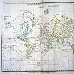
Map of the World
The World, showing Captain James Cooks voyages from 1768 - 1775, based on Mercators Projection, published by William Faden 1778 Date: 1778
Mary Evans Picture Library makes available wonderful images created for people to enjoy over the centuries
Media ID 7402983
© Mary Evans Picture Library 2015 - https://copyrighthub.org/s0/hub1/creation/maryevans/MaryEvansPictureID/10474576
Greetings Card (7"x5")
"Discover the rich history of exploration with our exquisite "Map of the World" Greeting Cards from Media Storehouse. This stunning design, sourced from Mary Evans Prints Online, showcases an intricately detailed map of the world as it was known during Captain James Cook's voyages from 1768 to 1775. Based on Mercator's Projection and published by William Faden in 1778, these cards transport you back in time, making for a thoughtful and unique gift for history enthusiasts or cartography lovers. Each card comes with a blank interior for your personal message, allowing you to add a touch of history to your correspondence."
Folded Greeting Cards (12.5x17.5 cm) have a laminate finish and are supplied with an envelope. The front and inside can be personalised with text in a selection of fonts, layouts and colours.
Greetings Cards suitable for Birthdays, Weddings, Anniversaries, Graduations, Thank You and much more
Estimated Product Size is 12.5cm x 17.5cm (4.9" x 6.9")
These are individually made so all sizes are approximate
Artwork printed orientated as per the preview above, with landscape (horizontal) or portrait (vertical) orientation to match the source image.
FEATURES IN THESE COLLECTIONS
> Arts
> Artists
> F
> William Faden
> Arts
> Artists
> J
> William James
> Maps and Charts
> Related Images
> Maps and Charts
> World
> Mary Evans Prints Online
> National Archives
EDITORS COMMENTS
1. Title: "Journeying the Unknown: Captain James Cook's Voyages of Discovery (1768-1775), as depicted in the 1778 Map of the World by William Faden" 2.. This map print, published by renowned cartographer William Faden in 1778, showcases the world as it was known during the Age of Discovery, with a focus on the groundbreaking voyages of Captain James Cook between 1768 and 1775. Based on the Mercator projection, this map is a testament to the spirit of exploration and the expanding horizons of the 18th century. 3. Background: The map illustrates the world as it was understood during the late 1700s, with Cook's significant explorations highlighted in vibrant red. Cook's voyages, which began in 1768, marked a pivotal period in European maritime history. Cook's expeditions led to the discovery of New Zealand, the eastern coast of Australia, and numerous Pacific islands, significantly expanding the world's geographical knowledge. 4. Detailed Exploration: The map meticulously charts Cook's routes, revealing the vast territories he traversed. His first voyage took him to the Pacific Ocean, where he explored New Zealand and the eastern coast of Australia. His second voyage, which began in 1772, led him to the Hawaiian Islands, Alaska, and the North Pacific. Cook's third and final voyage, which ended tragically in 1779, focused on the exploration of the Antarctic Circle. 5. Historical Significance: This map is an essential historical document, providing a visual representation of the world as it was known during the late 18th century and highlighting the remarkable achievements of Captain James Cook's voyages of discovery. The map serves as a reminder of the curiosity, courage, and determination of the explorers of this era, who ventured into the unknown to expand human knowledge and understanding of the world.
MADE IN AUSTRALIA
Safe Shipping with 30 Day Money Back Guarantee
FREE PERSONALISATION*
We are proud to offer a range of customisation features including Personalised Captions, Color Filters and Picture Zoom Tools
SECURE PAYMENTS
We happily accept a wide range of payment options so you can pay for the things you need in the way that is most convenient for you
* Options may vary by product and licensing agreement. Zoomed Pictures can be adjusted in the Cart.