Home > Arts > Contemporary art > Sculpture > Landscape paintings
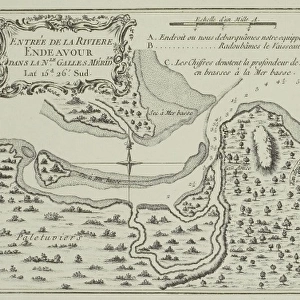
Polynesia, Tahiti Island and the Marquesas Islands, engraving based on maps drawn by James Cook

![]()
Wall Art and Photo Gifts from Universal Images Group (UIG)
Polynesia, Tahiti Island and the Marquesas Islands, engraving based on maps drawn by James Cook
History of Exploration, 18th century. Polynesia, Tahiti Island and the Marquesas Islands. Engraving based upon the maps drawn by James Cook
Universal Images Group (UIG) manages distribution for many leading specialist agencies worldwide
Media ID 9505285
© DEA / G. DE VECCHI
18th Century Aerial View Archipelago Border Coastline Colonialism Direction Guidance Island Marquesas Islands Navigational Equipment Polynesia Tahiti Tahiti Island Text Western Script Non Urban Scene
FEATURES IN THESE COLLECTIONS
> Aerial Photography
> Related Images
> Arts
> Art Movements
> Landscapes
> Arts
> Contemporary art
> Landscapes
> Sculptures
> Arts
> Contemporary art
> Sculpture
> Landscape paintings
> Arts
> Landscape paintings
> Landscape art
> Landscape paintings
> Arts
> Landscape paintings
> Landscape art
> Arts
> Street art graffiti
> Urban art
> Landscape paintings
> Universal Images Group (UIG)
> Art
> Painting, Sculpture & Prints
> Cartography
EDITORS COMMENTS
This engraving takes us back to the 18th century, offering a glimpse into the history of exploration and colonialism in Polynesia. Based on maps meticulously drawn by James Cook, this print showcases the enchanting beauty of Tahiti Island and the Marquesas Islands. The topography of these islands is intricately depicted, with their lush landscapes and azure seas stretching as far as the eye can see. As we observe this aerial view, our eyes are drawn to the intricate details etched onto this piece of art. The Western script text provides guidance and direction, allowing us to navigate through this archipelago with ease. It serves as a testament to early cartography techniques and navigational equipment used during that era. The solitary figure portrayed in this illustration adds depth to the scene, reminding us of human presence amidst nature's grandeur. This non-urban setting invites contemplation about life on these remote islands centuries ago. Through this engraved image, we are transported back in time - a window into Polynesia's past. It sparks curiosity about how these lands were discovered and colonized by explorers like Cook. Letting our imagination wander across Tahiti Island's coastline and beyond its borders towards the Marquesas Islands, we appreciate both the artistic craftsmanship involved in creating such an exquisite print and its historical significance for understanding Polynesian culture and heritage.
MADE IN AUSTRALIA
Safe Shipping with 30 Day Money Back Guarantee
FREE PERSONALISATION*
We are proud to offer a range of customisation features including Personalised Captions, Color Filters and Picture Zoom Tools
SECURE PAYMENTS
We happily accept a wide range of payment options so you can pay for the things you need in the way that is most convenient for you
* Options may vary by product and licensing agreement. Zoomed Pictures can be adjusted in the Cart.