Home > Arts > Contemporary art > Sculpture > Landscape paintings
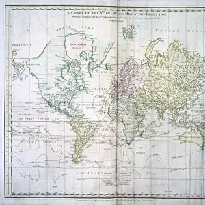
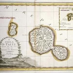
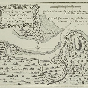
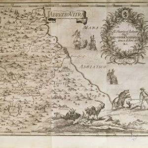
Polynesia, the Society and Christmas Islands, engraving based on maps drawn by James Cook

![]()
Wall Art and Photo Gifts from Universal Images Group (UIG)
Polynesia, the Society and Christmas Islands, engraving based on maps drawn by James Cook
History of Exploration, 18th century. Polynesia, the Society and Christmas Islands. Engraving based upon the maps drawn by James Cook
Universal Images Group (UIG) manages distribution for many leading specialist agencies worldwide
Media ID 9505041
© DEA / G. DE VECCHI
18th Century Aerial View Archipelago Border Coastline Colonialism Direction Guidance Island Navigational Equipment Polynesia Text Western Script Christmas Island Non Urban Scene Society Island
FEATURES IN THESE COLLECTIONS
> Aerial Photography
> Related Images
> Arts
> Art Movements
> Landscapes
> Arts
> Contemporary art
> Landscapes
> Sculptures
> Arts
> Contemporary art
> Sculpture
> Landscape paintings
> Arts
> Landscape paintings
> Landscape art
> Landscape paintings
> Arts
> Landscape paintings
> Landscape art
> Arts
> Street art graffiti
> Urban art
> Landscape paintings
> Special Days
> Christmas
> Related Images
> Universal Images Group (UIG)
> Art
> Painting, Sculpture & Prints
> Cartography
EDITORS COMMENTS
This print takes us back to the 18th century, showcasing Polynesia's Society and Christmas Islands as depicted by renowned explorer James Cook. The engraving is a testament to the history of exploration, shedding light on the colonial era and its impact on these remote island territories. The intricate details of this map-based illustration allow us to delve into the topography of these archipelagos, guiding our imagination through their lush landscapes and azure seas. With Western script providing direction and context, it serves as a navigational tool for both travelers and historians alike. From an aerial perspective, we witness the non-urban scenes that once dominated these islands. The coastline stretches out before us in all its natural beauty, reminding us of a time when human presence was minimal compared to today. One person can be seen amidst this vast expanse, perhaps symbolizing Cook himself or any brave adventurer who dared to explore these uncharted lands. Their presence emphasizes the significance of cartography in uncovering new frontiers during an era where technology was limited. As an engraved image crafted with precision and artistry, this print encapsulates not only Polynesia's rich history but also serves as a reminder of how far we have come in terms of understanding our world. It invites contemplation about our relationship with colonialism while appreciating the remarkable achievements made by explorers like James Cook.
MADE IN AUSTRALIA
Safe Shipping with 30 Day Money Back Guarantee
FREE PERSONALISATION*
We are proud to offer a range of customisation features including Personalised Captions, Color Filters and Picture Zoom Tools
SECURE PAYMENTS
We happily accept a wide range of payment options so you can pay for the things you need in the way that is most convenient for you
* Options may vary by product and licensing agreement. Zoomed Pictures can be adjusted in the Cart.