Greetings Card : USA, satellite image
![]()

Cards from Science Photo Library
USA, satellite image
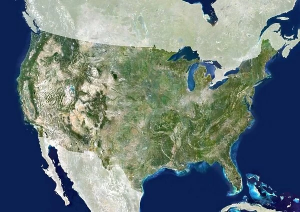
USA, satellite image. North is at top. The USA consists of the lower 48 states (shown). The Pacific islands of Hawaii and Alaska, which is separated from the lower 48 states by Canada, make up the other two states (not shown). The USA borders Canada to the north and Mexico to the south. The Gulf of Mexico forms the southeast coast of the USA. The Pacific west coast of the USA is dominated by the Rocky Mountains. The Great Lakes in the northwest are the largest group of freshwater lakes on Earth. The USAs Capital city, Washington and largest city, New York are located on the Atlantic coast
Science Photo Library features Science and Medical images including photos and illustrations
Media ID 6351919
© PLANETOBSERVER/SCIENCE PHOTO LIBRARY
Atlantic Ocean Canada Caribbean Countries Country Earth Observation Earth Science From Space Lakes Mexico Mountains Nation Nations North American Pacific Ocean Plains Rocky Mountains Satellite Image Sciences Topography Us A Great Lakes Great Plains
Greetings Card (7"x5")
Discover the beauty of the USA in our Media Storehouse Greeting Cards collection. Featuring a stunning satellite image of the lower 48 states from Science Photo Library, these cards showcase the unique geography of the USA with Hawaii and Alaska clearly visible. Perfect for expressing a thoughtful message, these cards are a unique and captivating way to connect with friends and loved ones.
Folded Greeting Cards (12.5x17.5 cm) have a laminate finish and are supplied with an envelope. The front and inside can be personalised with text in a selection of fonts, layouts and colours.
Greetings Cards suitable for Birthdays, Weddings, Anniversaries, Graduations, Thank You and much more
Estimated Product Size is 12.5cm x 17.5cm (4.9" x 6.9")
These are individually made so all sizes are approximate
Artwork printed orientated as per the preview above, with landscape (horizontal) or portrait (vertical) orientation to match the source image.
EDITORS COMMENTS
This satellite image showcases the vast and diverse landscape of the United States. With North at the top, this print beautifully captures the lower 48 states that make up the majority of the country's territory. However, it is important to note that two significant regions are not shown in this image: Alaska and Hawaii. The USA shares its borders with Canada to the north and Mexico to the south, while its southeast coast is defined by the Gulf of Mexico. The Pacific west coast boasts stunning views dominated by the majestic Rocky Mountains. Meanwhile, nestled in Northwest America lies a remarkable cluster known as the Great Lakes - Earth's largest group of freshwater lakes. On closer inspection, one can spot Washington D. C. , serving as both capital city and political hub of this great nation. Alongside it lies New York City, standing tall on America's bustling Atlantic coast. This print from Science Photo Library offers an incredible perspective on American geography and topography. It highlights not only natural wonders like mountains, lakes, plains but also emphasizes key features such as GDP (Gross Domestic Product), which reflects economic strength. While we admire this breathtaking view captured from space through advanced satellite technology, let us appreciate how these images contribute to our understanding of Earth science and observation without commercial intent or mention thereof.
MADE IN AUSTRALIA
Safe Shipping with 30 Day Money Back Guarantee
FREE PERSONALISATION*
We are proud to offer a range of customisation features including Personalised Captions, Color Filters and Picture Zoom Tools
SECURE PAYMENTS
We happily accept a wide range of payment options so you can pay for the things you need in the way that is most convenient for you
* Options may vary by product and licensing agreement. Zoomed Pictures can be adjusted in the Cart.


