
Greetings Card > Animals > Mammals > Cats (Wild) > Lion
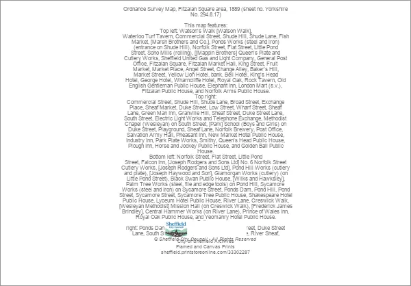
Greetings Card : Ordnance Survey Map, Fitzalan Square area, 1889 (sheet no. Yorkshire No. 294.8.17)
")
")

![]()
Cards from Sheffield City Archives
Ordnance Survey Map, Fitzalan Square area, 1889 (sheet no. Yorkshire No. 294.8.17)
This map features:
Top left: Watson's Walk [Watson Walk], Waterloo Turf Tavern, Commercial Street, Shude Hill, Shude Lane, Fish Market, [Marsh Brothers and Co.], Ponds Works (steel and iron) (entrance on Shude Hill), Norfolk Street, Flat Street, Little Pond Street, Soho Mills (rolling), [[Mappin Brothers] Queen's Plate and Cutlery Works, Sheffield United Gas and Light Company, General Post Office, Fitzalan Square, Fitzalan Market Hall, King Street, Fruit Market, Market Place, Angel Street, Change Alley, Baker's Hill, Market Street, Yellow Lion Hotel, bank, Bell Hotel, King's Head Hotel, George Hotel, Wharncliffe Hotel, Royal Oak, Rock Tavern, Old English Gentleman Public House, Elephant Inn, London Mart (s.v.), Fitzalan Public House, and Norfolk Arms Public House.
Top right: Commercial Street, Shude Hill, Shude Lane, Broad Street, Exchange Place, Sheaf Market, Duke Street, Low Street, Wharf Street, Sheaf Lane, Green Man Inn, Granville Hill, Sheaf Street, Duke Street Lane, South Street, Electric Light Works and Telephone Exchange, Methodist Chapel (Wesleyan) on South Street, [Park] School (Boys and Girls) on Duke Street, Playground, Sheaf Lane, Norfolk Brewery, Post Office, Salvation Army Hall, Pheasant Inn, New Market Hotel Public House, Industry Inn, Park Plate Works, Smithy, Queen's Head Public House, Plough Inn, Horse and Jockey Public House, and Golden Ball Public House.
Bottom left: Norfolk Street, Flat Street, Little Pond Street, Falcon Inn, [Joseph Rodgers and Sons Ltd] No. 6 Norfolk Street Cutlery Works, [Joseph Rodgers and Sons Ltd], Pond Hill Works (cutlery and plate), [Joseph Haywood and Son], Glamorgan Works (cutlery) (on Little Pond Street), Black Swan Public House, [Wilks and Hawksley], Palm Tree Works (steel, file and edge tools) on Pond Hill, Sycamore Works (steel and Iron) on Sycamore Street, Ponds Dam, Pond Hill, Pond Street, Sycamore Street, Sycamore Tree Public House, Shakespeare Hotel Public House, Lyceum Hotel Public House, River Lane, Creswick Walk, [Wesleyan Methodist] Mission Hall (on Creswick Walk), [Frederick James Brindley], Central Hammer Works (on River Lane), Prince of Wales Inn, Royal Oak Public House, and Yeomanry Hotel Public House.
Bottom right: Ponds Dam, Pond Hill, Granville Hill, Sheaf Street, Duke Street Lane, South Street, Sheaf Mill (corn), Ponds Forge, River Sheaf, Dyer's Bridge, Anson Street, Lord Street, Gilbert Street, Midland Railway, Hague Street, Granville Street, Sheaf Island, Sheaf Island Works (steel and iron), Sun Inn, Napier Hotel Public House, Oxford Hotel Public House, Reindeer Public House, and Shude Lane.
Additional information from White's General and Commercial Directory of Sheffield, 1896 / Graces Guide.
Surveyed 1889.
Dimensions of original: 77 x 102 cm.
Scale 10.56 feet : 1 mile [1:500]
From an original at Sheffield Libraries: q00083 (sheet no. Yorkshire No. 294.8.17)
Sheffield City Archives and Local Studies Library has an unrivalled collection of images of Sheffield, England
Media ID 33302287
© Sheffield City Council - All Rights Reserved
Old Map Ordnance Survey Os Map Sheffield
Greetings Card (7"x5")
Step back in time with our unique Ordnance Survey Greetings Cards from Media Storehouse. This charming design features an historic map of Sheffield's Fitzalan Square area, dated 1889 (Sheet No. Yorkshire No. 294.8.17) from Sheffield City Archives. Discover the intriguing details of this vintage map, including Watson's Walk, Waterloo Turf Tavern, Commercial Street, Shude Hill, Shude Lane, Fish Market, and Marsh Brothers and Co. These beautifully crafted greetings cards are the perfect way to add a touch of history to your correspondence. Send a piece of the past to your loved ones and let them explore the stories hidden within.
Folded Greeting Cards (12.5x17.5 cm) have a laminate finish and are supplied with an envelope. The front and inside can be personalised with text in a selection of fonts, layouts and colours.
Greetings Cards suitable for Birthdays, Weddings, Anniversaries, Graduations, Thank You and much more
Estimated Product Size is 12.5cm x 17.5cm (4.9" x 6.9")
These are individually made so all sizes are approximate
Artwork printed orientated as per the preview above, with landscape (horizontal) or portrait (vertical) orientation to match the source image.
FEATURES IN THESE COLLECTIONS
> Animals
> Mammals
> Cats (Wild)
> Lion
> Sheffield City Archives
> Maps and Plans
> Sheffield OS maps
EDITORS COMMENTS
This print showcases an Ordnance Survey Map of the Fitzalan Square area in 1889. The map, sheet no. Yorkshire No. 294.8.17, provides a fascinating glimpse into the bustling streets and landmarks of Sheffield during this era. In the top left corner, we can spot Watson's Walk, Waterloo Turf Tavern, Commercial Street, Shude Hill, Fish Market, and various other notable locations. Ponds Works stands out with its steel and iron production entrance on Shude Hill. Mappin Brothers' Queen's Plate and Cutlery Works also make their mark alongside prominent establishments like Sheffield United Gas and Light Company and the General Post Office. Moving to the top right section of the map reveals Commercial Street, Sheaf Market, Low Street, Electric Light Works and Telephone Exchange among others. Noteworthy buildings such as Wesleyan Methodist Chapel on South Street and [Park] School for Boys and Girls add depth to this historical snapshot. The bottom left quadrant highlights Norfolk Street along with Joseph Rodgers & Sons Ltd Cutlery Works on Flat Street. Other significant features include Palm Tree Works by Wilks & Hawksley on Pond Hill and Sycamore Works on Sycamore Street. Lastly, in the bottom right corner lies Granville Hill leading to Sheaf Mill (corn), River Sheaf flowing under Dyer's Bridge towards Anson Street. This remarkable piece of history was surveyed in 1889 with dimensions measuring 77 x 102 cm at a scale of 10.56 feet:1 mile [1:500]. Preserved at Sheffield Libraries under reference q00083 (sheet no. Yorkshire No. 2948 . 17), it offers invaluable insights into Sheffield's past that continue to captivate us today.
MADE IN AUSTRALIA
Safe Shipping with 30 Day Money Back Guarantee
FREE PERSONALISATION*
We are proud to offer a range of customisation features including Personalised Captions, Color Filters and Picture Zoom Tools
SECURE PAYMENTS
We happily accept a wide range of payment options so you can pay for the things you need in the way that is most convenient for you
* Options may vary by product and licensing agreement. Zoomed Pictures can be adjusted in the Cart.

