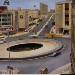
Greetings Card > Europe > United Kingdom > England > Yorkshire > Clifton
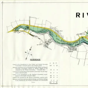
Greetings Card : Ordnance Survey Map, Kelvin area of Sheffield, 1889 (Yorkshire sheet 294. 3. 24)
")
")

![]()
Cards from Sheffield City Archives
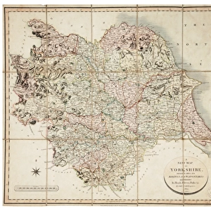
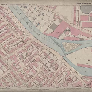
Ordnance Survey Map, Kelvin area of Sheffield, 1889 (Yorkshire sheet 294. 3. 24)
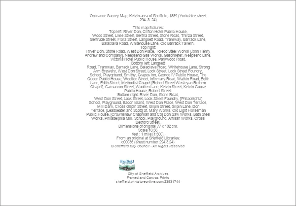
This map features:
Top left: River Don, Clifton Hotel Public House, Wood Street, Lime Street, Bertha Street, Stone Road, Thirza Street, Gertrude Street, Flora Street, Langsett Road, Tramway, Barrack Lane, Balaclava Road, Whitehouse Lane, Old Barrack Tavern.
Top right: River Don, Stone Road, West Don Place, Toledo Steel Works [John Henry Andrew and Company], Neepsend Gas Works, Gasometer, Neepsend Lane, Victoria Hotel Public House, Parkwood Road.
Bottom left: Langsett Road, Tramway, Barrack Lane, Balaclava Road, Whitehouse Lane, Strong Arm Brewery, West Don Street, Lock Street, Lock Street Foundry, School, Playground, Smithy, Grapes Inn, George IV Public House, The Queen Public House, Woollen Street, Infirmary Road, Watkin Road, Edith Lane, Edith Street, Methodist Chapel [Robert Street Wesleyan Reform Chapel], Carnarvon Street, Woollen Lane, Kelvin Street, Kelvin Goose Public House, Robert Street.
Bottom right: River Don, Stone Road, West Don Street, Lock Street, Lock Street Foundry, [Philadelphia] School, Playground, Bacon Island, West Don Place, West Don Terrace, Mill Dam, Cross Gilpin Street, Gilpin Street, Gilpin Lane, Don Terrace, [Leadbeater and Scott] St. Mary Works, Old Light Horseman Public House, [Crownshaw Chapman and Co] Don Saw Works, Bath Steel Works, Philadelphia Mill, School, Playground, Artisan Works, Cross Bedford Street.
Dimensions of original 77 x 102 cm.
Scale 10.56 feet : 1 mile [1:500].
From an original at Sheffield Libraries: q00036 (sheet number 294.3.24)
Sheffield City Archives and Local Studies Library has an unrivalled collection of images of Sheffield, England
Media ID 23931744
© Sheffield City Council - All Rights Reserved
Ordnance Survey Os Map Sheffield Kelvin
Greetings Card (7"x5")
Step back in time with our unique Ordnance Survey Map Greetings Cards from Media Storehouse. This charming design features a historic map of the Kelvin area of Sheffield, dated 1889 (Yorkshire sheet 294.3.24), obtained from Sheffield City Archives. The intricate details of the map include notable landmarks such as the River Don, Clifton Hotel Public House, Wood Street, Lime Street, Bertha Street, Stone Road, Thirza Street, Gertrude Street, Flora Street, Langsett Road, and the Tramway. These beautifully designed greeting cards are the perfect way to add a touch of history to your correspondence. Send a piece of the past to your loved ones today!
Folded Greeting Cards (12.5x17.5 cm) have a laminate finish and are supplied with an envelope. The front and inside can be personalised with text in a selection of fonts, layouts and colours.
Greetings Cards suitable for Birthdays, Weddings, Anniversaries, Graduations, Thank You and much more
Estimated Product Size is 12.5cm x 17.5cm (4.9" x 6.9")
These are individually made so all sizes are approximate
Artwork printed orientated as per the preview above, with landscape (horizontal) or portrait (vertical) orientation to match the source image.
FEATURES IN THESE COLLECTIONS
> Animals
> Insects
> Hemiptera
> Grape Scale
> Arts
> Artists
> A
> John Andrew
> Arts
> Artists
> C
> John Chapman
> Arts
> Artists
> Q
> Queen Victoria Queen Victoria
> Arts
> Artists
> S
> John Scott
> Arts
> Artists
> W
> John George Wood
> Arts
> Artists
> W
> John Watkins
> Arts
> Artists
> W
> John Wood
> Europe
> United Kingdom
> England
> West Yorkshire
> Related Images
> Europe
> United Kingdom
> England
> Yorkshire
> Clifton
> Sheffield City Archives
> Maps and Plans
> Sheffield OS maps
EDITORS COMMENTS
This print showcases an Ordnance Survey Map of the Kelvin area in Sheffield, dating back to 1889. The map, known as Yorkshire sheet 294.3.24, provides a detailed glimpse into the past and offers a fascinating insight into the city's history. In the top left corner of the map, we can identify various landmarks such as the River Don, Clifton Hotel Public House, Wood Street, Lime Street, and Bertha Street. Moving further along, our eyes are drawn to notable streets like Thirza Street and Gertrude Street. The presence of Langsett Road and a tramway adds to the charm of this vintage depiction. The top right section reveals more intriguing elements including West Don Place and Toledo Steel Works by John Henry Andrew and Company. Neepsend Gas Works with its towering gasometer also finds its place on this historical document alongside Victoria Hotel Public House and Parkwood Road. As we shift our focus towards the bottom left portion of the map, Langsett Road once again takes center stage accompanied by Barrack Lane and Balaclava Road. Noteworthy establishments like Strong Arm Brewery make their mark here too while Robert Street Wesleyan Reform Chapel stands proudly as a religious landmark. Finally, in the bottom right corner lies Mill Dam alongside Gilpin Lane and Cross Bedford Street. We catch glimpses of Old Light Horseman Public House as well as Bath Steel Works within this bustling industrial landscape. With dimensions measuring 77 x 102 cm and a scale ratio of 10.56 feet : 1 mile (1:500), this remarkable piece from Sheffield Libraries' archives is truly an invaluable treasure for those seeking to explore Sheffield's rich heritage through cartography.
MADE IN AUSTRALIA
Safe Shipping with 30 Day Money Back Guarantee
FREE PERSONALISATION*
We are proud to offer a range of customisation features including Personalised Captions, Color Filters and Picture Zoom Tools
SECURE PAYMENTS
We happily accept a wide range of payment options so you can pay for the things you need in the way that is most convenient for you
* Options may vary by product and licensing agreement. Zoomed Pictures can be adjusted in the Cart.