Greetings Card > Europe > Italy > Lazio > Rome
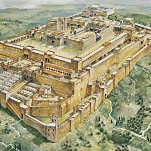
Greetings Card : Map of preroman Lazio, drawing


![]()
Cards from Universal Images Group (UIG)
Map of preroman Lazio, drawing
Ancient Rome. Map of pre-Roman Latium
Universal Images Group (UIG) manages distribution for many leading specialist agencies worldwide
Media ID 9472397
Aerial View Coastline Drawing Lazio Mediterranean Sea
Greetings Card (7"x5")
Discover the rich history of Ancient Rome with our exquisite selection of greeting cards from Media Storehouse. Featuring a captivating drawing of a Pre-Roman Latium map from Universal Images Group, these cards transport you back in time. Perfect for history enthusiasts or those with a deep appreciation for the ancient world, these cards add a touch of culture and sophistication to your message. Express your thoughts and feelings with a piece of history. Order yours today!
Folded Greeting Cards (12.5x17.5 cm) have a laminate finish and are supplied with an envelope. The front and inside can be personalised with text in a selection of fonts, layouts and colours.
Greetings Cards suitable for Birthdays, Weddings, Anniversaries, Graduations, Thank You and much more
Estimated Product Size is 17.5cm x 12.5cm (6.9" x 4.9")
These are individually made so all sizes are approximate
Artwork printed orientated as per the preview above, with landscape (horizontal) or portrait (vertical) orientation to match the source image.
FEATURES IN THESE COLLECTIONS
> Aerial Photography
> Related Images
> Arts
> Artists
> R
> Roman Roman
> Europe
> Italy
> Aerial Views
> Europe
> Italy
> Lazio
> Related Images
> Europe
> Italy
> Lazio
> Rome
> Historic
> Ancient civilizations
> Maps and Charts
> Early Maps
> Universal Images Group (UIG)
> Art
> Archeology
EDITORS COMMENTS
This print showcases a mesmerizing "Map of pre-Roman Lazio" that takes us back in time to the ancient civilization of Italy. The intricate drawing beautifully depicts the historical region of Latium, providing an invaluable glimpse into the rich history and physical geography of this area. With its aerial view perspective, one can marvel at the vastness and complexity of this ancient Roman landscape. The map's detailed cartography skillfully outlines the boundaries and coastline, highlighting its proximity to the magnificent Mediterranean Sea. This visual representation allows us to appreciate how these natural features influenced trade routes, cultural exchange, and strategic importance during that era. As we delve into this square image, devoid of any people but brimming with historical significance, our imagination is ignited by thoughts of bustling cities like Rome and their grand architectural wonders. It serves as a reminder that behind every modern city lies layers upon layers of fascinating past civilizations. This illustration and painting from Universal Images Group (UIG) not only offers a unique opportunity for history enthusiasts but also serves as an educational tool for students studying ancient Rome or Italian culture. Its artistic rendering adds an element of beauty to what might otherwise be seen as merely a geographical representation. While appreciating this remarkable piece, it is important to note that it should not be used for commercial purposes; instead, let us cherish it as a window into our collective heritage – reminding us how far we've come while honoring those who came before us.
MADE IN AUSTRALIA
Safe Shipping with 30 Day Money Back Guarantee
FREE PERSONALISATION*
We are proud to offer a range of customisation features including Personalised Captions, Color Filters and Picture Zoom Tools
SECURE PAYMENTS
We happily accept a wide range of payment options so you can pay for the things you need in the way that is most convenient for you
* Options may vary by product and licensing agreement. Zoomed Pictures can be adjusted in the Cart.