Home > Europe > France > Canton > Nord
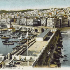
'Alger et ses environs; Afrique du nord, 1914. Creator: Unknown

![]()
Wall Art and Photo Gifts from Heritage Images
'Alger et ses environs; Afrique du nord, 1914. Creator: Unknown
'Alger et ses environs; Afrique du nord, 1914. From "Grande Geographie Bong Illustree", 1914
Heritage Images features heritage image collections
Media ID 36294625
© The Print Collector/Heritage Images
Algeria Algerian Algiers El Djazair Algeria Cartography Colonies Colony Map Making Mapmaking Mediterranean Sea North Africa North African Port
FEATURES IN THESE COLLECTIONS
> Africa
> Algeria
> Related Images
> Europe
> France
> Canton
> Nord
Alger et ses environs; Afrique du Nord, 1914
EDITORS COMMENTS
is a captivating black and white print depicting a detailed map of Algiers and its surroundings in North Africa. The map, created in the early 1910s, is an intriguing glimpse into the colonial era of Algeria, which was then a French territory. The map is titled "Alger et ses environs; Afrique du Nord" and was published in the renowned French geographical magazine "Grande Geographie Bong Illustree" in 1914. The map provides an extensive view of the Algerian coastline, with a particular focus on the Bay of Algiers. The intricate detailing of the map reveals the various geographical features of the region, including bays, capes, and islands. The map is a testament to the advanced cartography and mapmaking techniques of the early 20th century. It is also a reflection of the French colonial empire's extensive reach and influence in North Africa. The map highlights the strategic importance of Algeria as a port city and a hub for trade between Europe and the Mediterranean. The map is striking in its contrast of white and black, with the white lines and labels contrasting against the dark background. The use of shading to depict topographical features adds depth and texture to the map, making it a visually appealing and informative piece of historical cartography. The print also serves as a reminder of the complex history of Algeria and its relationship with France and Europe. The map's creation during a time of intense colonial activity in North Africa highlights the role that cartography and geographical knowledge played in the colonization and exploitation of African lands. Today, the map is a valuable historical artifact that offers insights into the geography and history of Algeria and North Africa during a pivotal period in world history.
MADE IN AUSTRALIA
Safe Shipping with 30 Day Money Back Guarantee
FREE PERSONALISATION*
We are proud to offer a range of customisation features including Personalised Captions, Color Filters and Picture Zoom Tools
SECURE PAYMENTS
We happily accept a wide range of payment options so you can pay for the things you need in the way that is most convenient for you
* Options may vary by product and licensing agreement. Zoomed Pictures can be adjusted in the Cart.