Home > Arts > Artists > S > Petrus Schenk
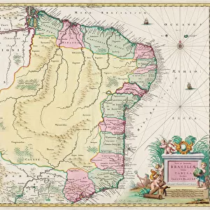
Map of the Baronie van Breda, c.1780. Creator: Nicolaes Visscher

![]()
Wall Art and Photo Gifts from Heritage Images
Map of the Baronie van Breda, c.1780. Creator: Nicolaes Visscher
Map of the Baronie van Breda, c.1780. At the top left list of towns and villages. At the top right the scale in German and French miles
Heritage Images features heritage image collections
Media ID 36341220
© Heritage Art/Heritage Images
Cartography Map Making Mapmaking Nicolaes Visscher Peter Schenk Region Scale Pieter Schenk Pieter Schenk I Watercolour Paint
FEATURES IN THESE COLLECTIONS
> Arts
> Artists
> S
> Petrus Schenk
> Arts
> Artists
> S
> Pieter Schenk
> Europe
> Netherlands
> Breda
> Europe
> Netherlands
> Maps
> Europe
> Netherlands
> Posters
> Europe
> Netherlands
> Related Images
> Maps and Charts
> Early Maps
EDITORS COMMENTS
This exquisite map print, titled "Map of the Baronie van Breda," dates back to the 18th century and was created by the renowned Dutch cartographer Nicolaes Visscher. The map provides a detailed and colorful representation of the Baronie van Breda region, located in the Netherlands. At the top left of the map, a list of towns and villages is neatly inscribed, while at the top right, the scale is presented in both German and French miles. Nicolaes Visscher, a prominent figure in the world of 18th-century cartography, is known for his meticulous attention to detail and his innovative approach to mapmaking. This map, produced in his workshop, showcases his exceptional skill in using watercolor paint to bring the landscape to life. The vibrant colors and intricate lines capture the character of the region, providing a glimpse into the past. The map is a testament to the rich heritage of the arts and sciences during the eighteenth century in Europe, particularly in the Low Countries. It is a valuable addition to any collection of historic maps or European art. The map's intricate details and beautiful aesthetics make it a fascinating piece for both historical and artistic appreciation. It is also worth noting that this map was produced in the workshop of Nicolaes Visscher, and not the well-known cartography company that bears the same name. Other notable cartographers associated with the workshop include Pieter Schenk the Elder and Petrus Schenck. The map's provenance adds to its historical significance and makes it a rare and valuable find for scholars and collectors alike.
MADE IN AUSTRALIA
Safe Shipping with 30 Day Money Back Guarantee
FREE PERSONALISATION*
We are proud to offer a range of customisation features including Personalised Captions, Color Filters and Picture Zoom Tools
SECURE PAYMENTS
We happily accept a wide range of payment options so you can pay for the things you need in the way that is most convenient for you
* Options may vary by product and licensing agreement. Zoomed Pictures can be adjusted in the Cart.