Home > North America > Canada > Maps
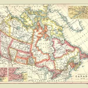
Political map of the Dominion of Canada

![]()
Wall Art and Photo Gifts from Heritage Images
Political map of the Dominion of Canada
Political map of the Dominion of Canada. Canada was known as the Dominion of Canada from 1867 until after the Second World War. Plate 82 from The Times Atlas
Heritage Images features heritage image collections
Media ID 15464888
© The Print Collector / Heritage-Images
Arctic Circle Canada Cartography Coastline Hudson Bay Hudsons Bay Map Making North America Dominion Of Canada
FEATURES IN THESE COLLECTIONS
> Maps and Charts
> Related Images
> Maps and Charts
> World
> North America
> Canada
> Maps
> North America
> Canada
> Related Images
EDITORS COMMENTS
This print showcases a historical gem - the political map of the Dominion of Canada. Steeped in rich heritage, this map represents an era from 1867 until after the Second World War when Canada was known as the Dominion of Canada. Plate 82 from The Times Atlas, it offers a fascinating glimpse into the country's past. The vibrant colors and intricate cartography bring to life every detail of this vast nation. From coast to coast, this comprehensive map highlights not only its geography but also its significance on North America's stage. The Arctic Circle stands out prominently, reminding us of Canada's northernmost reaches. One cannot help but be drawn to Hudson Bay and its surrounding coastline featured on this print. This iconic bay has played a crucial role in shaping Canadian history and trade routes for centuries. As we explore each location marked with precision on this map, we are transported back in time by The Print Collector's artistry. Their dedication to preserving our cultural heritage is evident through their meticulous craftsmanship. Let this remarkable piece ignite your curiosity about Canada's political evolution while appreciating the skillful artistry behind it. Whether you're an avid cartography enthusiast or simply captivated by history, let this print serve as a reminder that our world is shaped by both human ingenuity and natural wonders – all waiting to be discovered within these colorful contours.
MADE IN AUSTRALIA
Safe Shipping with 30 Day Money Back Guarantee
FREE PERSONALISATION*
We are proud to offer a range of customisation features including Personalised Captions, Color Filters and Picture Zoom Tools
SECURE PAYMENTS
We happily accept a wide range of payment options so you can pay for the things you need in the way that is most convenient for you
* Options may vary by product and licensing agreement. Zoomed Pictures can be adjusted in the Cart.