Jigsaw Puzzle > Europe > Macedonia > Maps
Jigsaw Puzzle : Map Growth Macedonia Rule Philip II Of Macedon


![]()
Jigsaw Puzzles from Design Pics
Map Growth Macedonia Rule Philip II Of Macedon
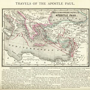
Map showing the growth of Macedonia under the rule of Philip II of Macedon, 382 - 336 BC. From the book Outline of History by H.G. Wells, published 1920
Design Pics offers Distinctively Different Imagery representing over 1,500 contributors
Media ID 32815093
© Ken Welsh
Cartography Chart Countries Geographical Geography Growth Macedonia Rule Philip Ii Of Macedon
Jigsaw Puzzle (500 Pieces)
Discover the rich history of ancient Macedonia with our captivating jigsaw puzzle from Media Storehouse. Featuring an intricately detailed map illustration by Ken Welsh from Design Pics, this puzzle depicts the growth of Macedonia under the rule of Philip II, the legendary king who expanded the kingdom from 382 to 336 BC. Immerse yourself in the fascinating history outlined in H.G. Wells' classic book, as you piece together this educational and engaging puzzle. Perfect for history enthusiasts, puzzle aficionados, or anyone looking for a thought-provoking challenge.
500 piece puzzles are custom made in Australia and hand-finished on 100% recycled 1.6mm thick laminated puzzle boards. There is a level of repetition in jigsaw shapes with each matching piece away from its pair. The completed puzzle measures 40x51cm and is delivered packaged in an attractive presentation box specially designed to fit most mail slots with a unique magnetic lid
Jigsaw Puzzles are an ideal gift for any occasion
Estimated Product Size is 40.3cm x 50.7cm (15.9" x 20")
These are individually made so all sizes are approximate
Artwork printed orientated as per the preview above, with landscape (horizontal) or portrait (vertical) orientation to match the source image.
FEATURES IN THESE COLLECTIONS
> Europe
> Macedonia
> Posters
> Europe
> Macedonia
> Related Images
> Maps and Charts
> Early Maps
> Maps and Charts
> North Macedonia
EDITORS COMMENTS
This print showcases the historical significance of Macedonia's growth under the rule of Philip II of Macedon, spanning from 382 to 336 BC. The intricate map, extracted from H. G. Wells' renowned book "Outline of History" published in 1920, offers a fascinating glimpse into the cartography and geography of that era. Engraved with meticulous detail, this archival piece serves as a valuable historical artifact. It vividly illustrates the expansion and territorial conquests achieved by Philip II during his reign. Each country is meticulously charted, providing an invaluable resource for historians and enthusiasts alike. The vintage aesthetic adds a touch of nostalgia to this period picture, transporting us back in time to witness Macedonia's transformation under Philip II's rule. As we gaze upon this illustration, we are reminded of the immense influence and power wielded by ancient civilizations. Ken Welsh has skillfully captured the essence of this historical gem through his photography expertise. This print not only preserves our collective heritage but also invites us to delve deeper into the rich tapestry woven by past civilizations. Whether displayed in educational institutions or private collections dedicated to history aficionados, this remarkable image sparks curiosity about ancient times while paying homage to one man's indelible mark on Macedonian history - Philip II of Macedon.
MADE IN AUSTRALIA
Safe Shipping with 30 Day Money Back Guarantee
FREE PERSONALISATION*
We are proud to offer a range of customisation features including Personalised Captions, Color Filters and Picture Zoom Tools
SECURE PAYMENTS
We happily accept a wide range of payment options so you can pay for the things you need in the way that is most convenient for you
* Options may vary by product and licensing agreement. Zoomed Pictures can be adjusted in the Cart.