Jigsaw Puzzle > South America > Brazil > Maps
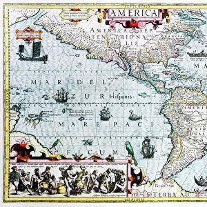
Jigsaw Puzzle : Map Of Northern Brazil, Circa. 1760. From "Atlas De Toutes Les Parties Connues Du Globe Terrestre "By Cartographer Rigobert Bonne. Published Geneva Circa. 1760


![]()
Jigsaw Puzzles from Design Pics
Map Of Northern Brazil, Circa. 1760. From "Atlas De Toutes Les Parties Connues Du Globe Terrestre "By Cartographer Rigobert Bonne. Published Geneva Circa. 1760
Map Of Northern Brazil, Circa.1760. From " Atlas De Toutes Les Parties Connues Du Globe Terrestre " By Cartographer Rigobert Bonne. Published Geneva Circa. 1760
Design Pics offers Distinctively Different Imagery representing over 1,500 contributors
Media ID 18186408
© Ken Welsh / Design Pics
Brazil Cartography Geography Mapmaking Northern Plate
Jigsaw Puzzle (1000 Pieces)
Discover the past with our captivating jigsaw puzzle from Media Storehouse. This intricately detailed puzzle features a historical map of Northern Brazil, circa 1760, taken from the "Atlas De Toutes Les Parties Connues Du Globe Terrestre" by renowned cartographer Rigobert Bonne. Published in Geneva around 1760, this map offers a fascinating glimpse into the geographical knowledge of the time. Immerse yourself in the puzzle's intricate design and uncover the stories hidden within the lines and borders. Perfect for history enthusiasts, puzzle collectors, or anyone seeking a challenging and rewarding activity. Piece together the past with our Media Storehouse jigsaw puzzle.
1000 piece puzzles are custom made in Australia and hand-finished on 100% recycled 1.6mm thick laminated puzzle boards. There is a level of repetition in jigsaw shapes with each matching piece away from its pair. The completed puzzle measures 76x50cm and is delivered packaged in an attractive presentation box specially designed to fit most mail slots with a unique magnetic lid
Jigsaw Puzzles are an ideal gift for any occasion
Estimated Product Size is 76cm x 50.2cm (29.9" x 19.8")
These are individually made so all sizes are approximate
Artwork printed orientated as per the preview above, with landscape (horizontal) or portrait (vertical) orientation to match the source image.
FEATURES IN THESE COLLECTIONS
> Maps and Charts
> Related Images
> South America
> Brazil
> Maps
> South America
> Brazil
> Related Images
EDITORS COMMENTS
This print showcases a remarkable piece of cartographic history - the Map of Northern Brazil, Circa. 1760. From "Atlas De Toutes Les Parties Connues Du Globe Terrestre" by renowned cartographer Rigobert Bonne, this exquisite engraving was published in Geneva around 1760. The map itself is a true testament to the artistry and precision of early mapmaking. Its vibrant colors and intricate details transport us back in time, offering a glimpse into the geographical knowledge and exploration of that era. As we delve into this horizontal illustration, we are immersed in the vastness and diversity of Northern Brazil's landscape. From lush rainforests to winding rivers, from sprawling coastlines to majestic mountains, every contour is meticulously depicted with utmost accuracy. Beyond its aesthetic appeal, this historical artifact serves as an invaluable resource for understanding the geography and topography of Northern Brazil during the 18th century. It provides valuable insights into how our perception of landforms has evolved over time. Ken Welsh's expertly captured photograph allows us to appreciate not only the beauty but also the significance of this antique map plate. It reminds us that maps are not just tools for navigation; they are windows into our past and gateways to discovering new horizons.
MADE IN AUSTRALIA
Safe Shipping with 30 Day Money Back Guarantee
FREE PERSONALISATION*
We are proud to offer a range of customisation features including Personalised Captions, Color Filters and Picture Zoom Tools
SECURE PAYMENTS
We happily accept a wide range of payment options so you can pay for the things you need in the way that is most convenient for you
* Options may vary by product and licensing agreement. Zoomed Pictures can be adjusted in the Cart.