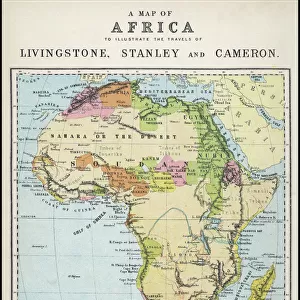
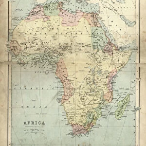
Jigsaw Puzzle > Africa > Madagascar > Maps
Jigsaw Puzzle : Map Of Southern Africa And Madagascar, Circa. 1760. From "Atlas De Toutes Les Parties Connues Du Globe Terrestre "By Cartographer Rigobert Bonne. Published Geneva Circa. 1760


![]()
Jigsaw Puzzles from Design Pics
Map Of Southern Africa And Madagascar, Circa. 1760. From "Atlas De Toutes Les Parties Connues Du Globe Terrestre "By Cartographer Rigobert Bonne. Published Geneva Circa. 1760
Map Of Southern Africa And Madagascar, Circa. 1760. From " Atlas De Toutes Les Parties Connues Du Globe Terrestre " By Cartographer Rigobert Bonne. Published Geneva Circa. 1760
Design Pics offers Distinctively Different Imagery representing over 1,500 contributors
Media ID 18186457
© Ken Welsh / Design Pics
Africa Cartography Geography Madagascar Mapmaking Plate Southern
Jigsaw Puzzle (1000 Pieces)
Discover the historical wonders of Southern Africa and Madagascar with our exquisite jigsaw puzzle from Media Storehouse. This intricately detailed puzzle features a rare map from the 1760 Atlas De Toutes Les Parties Connues Du Globe Terrestre by renowned cartographer Rigobert Bonne. Travel back in time as you piece together this captivating representation of the region, published in Geneva circa 1760. Immerse yourself in history and ignite your sense of adventure with every puzzle piece you place.
1000 piece puzzles are custom made in Australia and hand-finished on 100% recycled 1.6mm thick laminated puzzle boards. There is a level of repetition in jigsaw shapes with each matching piece away from its pair. The completed puzzle measures 76x50cm and is delivered packaged in an attractive presentation box specially designed to fit most mail slots with a unique magnetic lid
Jigsaw Puzzles are an ideal gift for any occasion
Estimated Product Size is 76cm x 50.2cm (29.9" x 19.8")
These are individually made so all sizes are approximate
Artwork printed orientated as per the preview above, with landscape (horizontal) or portrait (vertical) orientation to match the source image.
FEATURES IN THESE COLLECTIONS
> Africa
> Madagascar
> Maps
> Africa
> Madagascar
> Related Images
EDITORS COMMENTS
This print showcases a remarkable piece of cartography from the 18th century. The "Map Of Southern Africa And Madagascar, Circa. 1760" is an exquisite creation by renowned cartographer Rigobert Bonne, published in Geneva during the same era. The map itself is a true work of art, meticulously engraved and filled with vibrant colors that bring life to the geographical features it portrays. Its horizontal orientation allows for easy exploration of the vast southern region of Africa and the intriguing island of Madagascar. As we delve into this historical map, we are transported back in time to an era when knowledge about these lands was still evolving. It serves as a testament to human curiosity and our desire to understand and document our world. Every line on this plate tells a story - from rivers meandering through lush landscapes to mountain ranges reaching towards the sky. The careful attention to detail demonstrates Bonne's dedication as a cartographer, ensuring accuracy while also capturing the beauty inherent in nature's design. This print not only offers us insight into past explorations but also invites us to appreciate the artistry behind mapmaking itself. It reminds us that maps are not just tools for navigation; they can be windows into history and gateways for imagination. Ken Welsh has skillfully captured this historic treasure, allowing us all to marvel at its intricacies and ponder upon how much has changed since its creation over two centuries ago.
MADE IN AUSTRALIA
Safe Shipping with 30 Day Money Back Guarantee
FREE PERSONALISATION*
We are proud to offer a range of customisation features including Personalised Captions, Color Filters and Picture Zoom Tools
SECURE PAYMENTS
We happily accept a wide range of payment options so you can pay for the things you need in the way that is most convenient for you
* Options may vary by product and licensing agreement. Zoomed Pictures can be adjusted in the Cart.