Jigsaw Puzzle > North America > Mexico > Maps
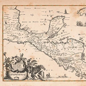
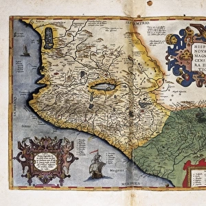
Jigsaw Puzzle : Map Of Southern Mexico, Circa. 1760. From "Atlas De Toutes Les Parties Connues Du Globe Terrestre "By Cartographer Rigobert Bonne. Published Geneva Circa. 1760


![]()
Jigsaw Puzzles from Design Pics
Map Of Southern Mexico, Circa. 1760. From "Atlas De Toutes Les Parties Connues Du Globe Terrestre "By Cartographer Rigobert Bonne. Published Geneva Circa. 1760
Map Of Southern Mexico, Circa.1760. From " Atlas De Toutes Les Parties Connues Du Globe Terrestre " By Cartographer Rigobert Bonne. Published Geneva Circa. 1760
Design Pics offers Distinctively Different Imagery representing over 1,500 contributors
Media ID 18186459
© Ken Welsh / Design Pics
Cartography Geography Mapmaking Mexico Plate Southern
Jigsaw Puzzle (1000 Pieces)
Discover the rich history of Southern Mexico with our exquisite Jigsaw Puzzle, featuring a rare map from the 18th century. Drawn by renowned cartographer Rigobert Bonne and published in Geneva circa 1760, this intriguing puzzle showcases an intricately detailed map of Southern Mexico from the "Atlas De Toutes Les Parties Connues Du Globe Terrestre." Immerse yourself in the past as you piece together this beautiful puzzle, each puzzle piece transporting you back in time. Perfect for history enthusiasts, puzzle lovers, or anyone seeking an engaging and educational activity. Unravel the mysteries of this captivating map and add a touch of history to your home or office.
1000 piece puzzles are custom made in Australia and hand-finished on 100% recycled 1.6mm thick laminated puzzle boards. There is a level of repetition in jigsaw shapes with each matching piece away from its pair. The completed puzzle measures 76x50cm and is delivered packaged in an attractive presentation box specially designed to fit most mail slots with a unique magnetic lid
Jigsaw Puzzles are an ideal gift for any occasion
Estimated Product Size is 76cm x 50.2cm (29.9" x 19.8")
These are individually made so all sizes are approximate
Artwork printed orientated as per the preview above, with landscape (horizontal) or portrait (vertical) orientation to match the source image.
FEATURES IN THESE COLLECTIONS
> Maps and Charts
> Related Images
> North America
> Mexico
> Maps
> North America
> Mexico
> Related Images
EDITORS COMMENTS
This print showcases a stunning map of Southern Mexico, dating back to the year 1760. Taken from the renowned "Atlas De Toutes Les Parties Connues Du Globe Terrestre" by esteemed cartographer Rigobert Bonne and published in Geneva during the same period, this piece is a true testament to the artistry and precision of historical mapmaking. The vibrant colors and intricate details of this engraving make it an absolute masterpiece. Every contour, river, and city is meticulously depicted, offering viewers a glimpse into the geographical landscape of Southern Mexico as it was understood over two centuries ago. Displayed horizontally, this illustration exudes elegance and sophistication. It serves as both an educational tool for geography enthusiasts and a work of art that can enhance any space with its timeless charm. Ken Welsh's expert photography captures every nuance of this remarkable print, allowing us to appreciate its beauty in great detail. Whether you are fascinated by history or simply drawn to visually striking imagery, this print will undoubtedly captivate your imagination.
MADE IN AUSTRALIA
Safe Shipping with 30 Day Money Back Guarantee
FREE PERSONALISATION*
We are proud to offer a range of customisation features including Personalised Captions, Color Filters and Picture Zoom Tools
SECURE PAYMENTS
We happily accept a wide range of payment options so you can pay for the things you need in the way that is most convenient for you
* Options may vary by product and licensing agreement. Zoomed Pictures can be adjusted in the Cart.