Jigsaw Puzzle > Fine Art Finder > Artists > John Seller
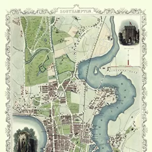
Jigsaw Puzzle : A chart of the West Indies from Cape Cod to River Oronoque from Atlas maritimus by John Seller


Please select a smaller print size for this image
![]()
Jigsaw Puzzles from Fine Art Finder
A chart of the West Indies from Cape Cod to River Oronoque from Atlas maritimus by John Seller
XOS1765716 A chart of the West Indies from Cape Cod to River Oronoque from Atlas maritimus by John Seller, 1682 (hand coloured engraving) by Seller, John (1632-97); 12x14 cm; New York Public Library, USA; (add.info.: Atlas maritimus, or, A sea-atlas : describing the sea-coasts in most of the known parts of the world
Seller was Hydrographer to the King and responsible for the first English Pilots.); English, out of copyright
Media ID 12742617
© www.bridgemanimages.com
American Indian Atlantic Ocean Atlas British Colony Caribbean Caribbean Sea Central America Colonial America Gulf Of Mexico Hydrography Islands Navigation Orinoco Pilot Sea Chart Tropic Of Cancer
Jigsaw Puzzle (500 Pieces)
Discover the captivating world of the West Indies with our exquisite jigsaw puzzles from Media Storehouse. Featuring the intricately detailed and hand-colored engraving "A chart of the West Indies from Cape Cod to River Oronoque" by renowned cartographer John Seller, these puzzles transport you back in time to the 17th century. Immerse yourself in the rich history and beauty of this iconic map, meticulously reproduced for your puzzling pleasure. Challenge yourself or enjoy with family and friends, this intriguing jigsaw puzzle is a must-have for history buffs, cartography enthusiasts, and puzzle lovers alike.
500 piece puzzles are custom made in Australia and hand-finished on 100% recycled 1.6mm thick laminated puzzle boards. There is a level of repetition in jigsaw shapes with each matching piece away from its pair. The completed puzzle measures 40x51cm and is delivered packaged in an attractive presentation box specially designed to fit most mail slots with a unique magnetic lid
Jigsaw Puzzles are an ideal gift for any occasion
Estimated Product Size is 50.7cm x 40.3cm (20" x 15.9")
These are individually made so all sizes are approximate
Artwork printed orientated as per the preview above, with landscape (horizontal) or portrait (vertical) orientation to match the source image.
EDITORS COMMENTS
This print showcases a remarkable piece of cartographic history - "A chart of the West Indies from Cape Cod to River Oronoque" by John Seller. Created in 1682, this hand-colored engraving is part of the renowned Atlas maritimus collection. As Hydrographer to the King, Seller was instrumental in producing the first English Pilots and played a significant role in shaping navigation practices during his time. The intricately detailed map spans an area from Cape Cod to River Oronoque, encompassing Mexico, Central America, and parts of North and South America. It offers a fascinating glimpse into colonial America and British territories during the era of discovery and exploration. With its vibrant colors and precise markings, this sea chart provides invaluable information for sailors navigating through treacherous waters. From coastlines to islands, from the Gulf of Mexico to the Caribbean Sea, every detail has been meticulously recorded. Beyond its navigational significance, this artwork also serves as a historical document capturing Native American settlements along with early British colonies that would later become part of what we now know as the United States. As you gaze upon this extraordinary print, immerse yourself in centuries past when brave explorers embarked on perilous journeys across vast oceans using maps like these as their guiding stars. Let it transport you back to an age where maritime adventures shaped our understanding of the world's geography.
MADE IN AUSTRALIA
Safe Shipping with 30 Day Money Back Guarantee
FREE PERSONALISATION*
We are proud to offer a range of customisation features including Personalised Captions, Color Filters and Picture Zoom Tools
SECURE PAYMENTS
We happily accept a wide range of payment options so you can pay for the things you need in the way that is most convenient for you
* Options may vary by product and licensing agreement. Zoomed Pictures can be adjusted in the Cart.