Jigsaw Puzzle > Asia > Georgia > Maps
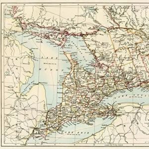
Jigsaw Puzzle : Map of the United States of 1803 showing the partition of the state (Kentucky, Tennessee, Georgia, Florida, Carolina, Virginia, Massachusetts, Indian territories, English Canada and Louisiana claimed by the French)
")
")


![]()
Jigsaw Puzzles From Fine Art Finder
Map of the United States of 1803 showing the partition of the state (Kentucky, Tennessee, Georgia, Florida, Carolina, Virginia, Massachusetts, Indian territories, English Canada and Louisiana claimed by the French)
NWI4901249 Map of the United States of 1803 showing the partition of the state (Kentucky, Tennessee, Georgia, Florida, Carolina, Virginia, Massachusetts, Indian territories, English Canada and Louisiana claimed by the French). (Map of the United States in 1803, showing the Louisiana Purchase); (add.info.: Map of the United States of 1803 showing the partition of the state (Kentucky, Tennessee, Georgia, Florida, Carolina, Virginia, Massachusetts, Indian territories, English Canada and Louisiana claimed by the French). (Map of the United States in 1803, showing the Louisiana Purchase)); Photo © North Wind Pictures
Media ID 38100784
© © North Wind Pictures / Bridgeman Images
America Continent Canadians Etats Unis Etats Unis Usa United States Geographical Map
Jigsaw Puzzle (1000 Pieces)
Embark on a journey through history with our captivating jigsaw puzzle featuring the Map of the United States in 1803. Explore the intricate details of state partitions and French claims, beautifully captured by Bridgeman Images from Fine Art Finder. Perfect for history buffs and puzzle enthusiasts alike!
1000 piece puzzles are custom made in Australia and hand-finished on 100% recycled 1.6mm thick laminated puzzle boards. There is a level of repetition in jigsaw shapes with each matching piece away from its pair. The completed puzzle measures 76x50cm and is delivered packaged in an attractive presentation box specially designed to fit most mail slots with a unique magnetic lid
Jigsaw Puzzles are an ideal gift for any occasion
Estimated Product Size is 76cm x 50.2cm (29.9" x 19.8")
These are individually made so all sizes are approximate
Artwork printed orientated as per the preview above, with landscape (horizontal) or portrait (vertical) orientation to match the source image.
FEATURES IN THESE COLLECTIONS
> Asia
> Georgia
> Related Images
> Maps and Charts
> Early Maps
> Maps and Charts
> Related Images
> North America
> Canada
> Maps
> North America
> Canada
> Related Images
EDITORS COMMENTS
This stunning print of a Map of the United States from 1803 offers a fascinating glimpse into the historical partitioning of states during that time period. From Kentucky to Florida, Carolina to Massachusetts, this map showcases the diverse territories that made up the young nation at the turn of the 19th century.
One can't help but be intrigued by the intricate details on display, including Indian territories and English Canada, as well as Louisiana claimed by the French. The Louisiana Purchase is prominently featured, highlighting one of America's most significant land acquisitions in history.
The vibrant colors and precise engraving bring this piece to life, offering viewers a chance to explore America's past in vivid detail. It serves as a reminder of how far our country has come since those early days, while also honoring the rich tapestry of cultures and regions that have shaped our national identity.
Whether you're a history buff or simply appreciate fine artistry, this Map of the United States from 1803 is sure to captivate and inspire all who gaze upon it.
MADE IN AUSTRALIA
Safe Shipping with 30 Day Money Back Guarantee
FREE PERSONALISATION*
We are proud to offer a range of customisation features including Personalised Captions, Color Filters and Picture Zoom Tools
SECURE PAYMENTS
We happily accept a wide range of payment options so you can pay for the things you need in the way that is most convenient for you
* Options may vary by product and licensing agreement. Zoomed Pictures can be adjusted in the Basket.