Jigsaw Puzzle > Fine Art Storehouse > Map
Jigsaw Puzzle : antiquity, archival, cartography, continents, geographical, geography, historic, map


![]()
Jigsaw Puzzles from Fine Art Storehouse
antiquity, archival, cartography, continents, geographical, geography, historic, map
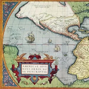
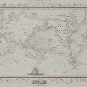
antiquity, archival, cartography, continents, geographical, geography, historic, map, maritime, nautical, navigating, navigation, new world, nobody, north america, old-fashioned, south america, text, vintage, Antique Maps, 87644096
Unleash your creativity and transform your space into a visual masterpiece!
Hemera Technologies
Media ID 14761274
© Getty Images
Antiquity Continents Geographical Geography Maritime Nautical Navigation New World North America South America Text Navigating
Jigsaw Puzzle (500 Pieces)
Discover the captivating world of history and geography with Media Storehouse's exquisite collection of Jigsaw Puzzles. Featuring breathtaking images from Hemera Technologies' Fine Art Storehouse, these puzzles transport you back in time with intricate depictions of antiquity, archives, cartography, continents, and more. Navigate through the intricacies of historic maps, maritime charts, and old-fashioned globes, as you piece together the puzzle of the New World, North and South America, and more. Each puzzle is a meticulously crafted work of art, sure to provide hours of engaging entertainment for the whole family. Bring the past to life and ignite your curiosity with Media Storehouse's captivating jigsaw puzzle collection.
500 piece puzzles are custom made in Australia and hand-finished on 100% recycled 1.6mm thick laminated puzzle boards. There is a level of repetition in jigsaw shapes with each matching piece away from its pair. The completed puzzle measures 40x51cm and is delivered packaged in an attractive presentation box specially designed to fit most mail slots with a unique magnetic lid
Jigsaw Puzzles are an ideal gift for any occasion
Estimated Product Size is 50.7cm x 40.3cm (20" x 15.9")
These are individually made so all sizes are approximate
Artwork printed orientated as per the preview above, with landscape (horizontal) or portrait (vertical) orientation to match the source image.
FEATURES IN THESE COLLECTIONS
> Fine Art Storehouse
> Map
> Historical Maps
EDITORS COMMENTS
This print by Hemera Technologies takes us on a journey back in time to the age of antiquity. The image showcases an exquisite antique map, filled with intricate details and historical significance. As we gaze upon this archival piece of cartography, we are transported to a world where continents were still being discovered and explored. The geographical accuracy depicted in this vintage map is truly remarkable. It captures the essence of navigating through uncharted waters, as maritime explorers sought to uncover new lands and expand their understanding of the world. The old-fashioned charm emanating from this historic artifact reminds us of the importance placed on accurate mapping during that era. With its focus on North America and South America, this map offers a glimpse into how these continents were perceived centuries ago. The text accompanying the illustration adds another layer of authenticity to its vintage appeal. As we admire this stunning piece, it serves as a reminder of our rich history and the tireless efforts made by early navigators who paved the way for our modern understanding of geography. This print is not just a decorative item but also an educational tool that sparks curiosity about our past.
MADE IN AUSTRALIA
Safe Shipping with 30 Day Money Back Guarantee
FREE PERSONALISATION*
We are proud to offer a range of customisation features including Personalised Captions, Color Filters and Picture Zoom Tools
SECURE PAYMENTS
We happily accept a wide range of payment options so you can pay for the things you need in the way that is most convenient for you
* Options may vary by product and licensing agreement. Zoomed Pictures can be adjusted in the Cart.